Approximate Location Map
Large Map »
Latitude: 52.0502 / 52°3'0"N
Longitude: -0.2005 / 0°12'1"W
OS Eastings: 523496
OS Northings: 240622
OS Grid: TL234406
Mapcode National: GBR J64.J3H
Mapcode Global: VHGN7.GQWN
Plus Code: 9C4X3Q2X+3R
Entry Name: Fir Trees
Listing Date: 19 November 1984
Grade: II
Source: Historic England
Source ID: 1102689
English Heritage Legacy ID: 162219
ID on this website: 101102689
Location: Hinxworth, North Hertfordshire, SG7
County: Hertfordshire
District: North Hertfordshire
Civil Parish: Hinxworth
Traditional County: Hertfordshire
Lieutenancy Area (Ceremonial County): Hertfordshire
Church of England Parish: Hinxworth
Church of England Diocese: St.Albans
Tagged with: Building
TL 24 SW HINXWORTH CHAPEL STREET
(North west side)
Hinxworth
1/107 Fir Trees
-
GV II
House. C16 or earlier gable-ended range with C19 left extension forming
L plan. Timber frame on right. Painted brick casing. Later C17 red brick
ridge chimney stack with vitrified brick dressings. 2 storeys. The gable
end has C19 sash windows to ground and 1st floor and a door on left, all
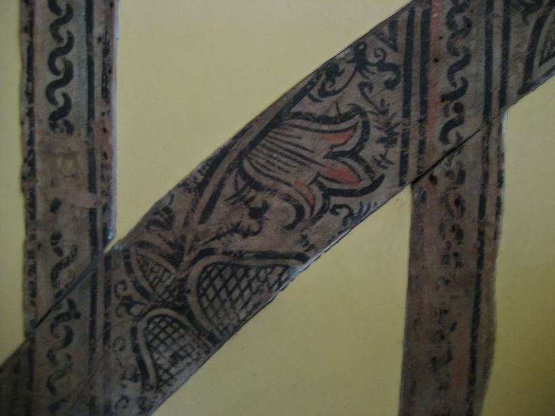
with thin flattened-arch hood moulds. Inside this range is evidence of
an extensive scheme of wall paintings in a ground floor room. Probably
late C16, only surviving on studs. Floral pattern in black, white and
red. (RCHM Typescript).
Listing NGR: TL2349240627
External links are from the relevant listing authority and, where applicable, Wikidata. Wikidata IDs may be related buildings as well as this specific building. If you want to add or update a link, you will need to do so by editing the Wikidata entry.


Other nearby listed buildings
