Approximate Location Map
Large Map »
Latitude: 51.7519 / 51°45'6"N
Longitude: -0.3445 / 0°20'40"W
OS Eastings: 514371
OS Northings: 207209
OS Grid: TL143072
Mapcode National: GBR H89.3QL
Mapcode Global: VHFS7.Z76B
Plus Code: 9C3XQM24+Q5
Entry Name: 2 and 4, Fishpool Street
Listing Date: 27 August 1971
Grade: II
Source: Historic England
Source ID: 1103137
English Heritage Legacy ID: 163232
ID on this website: 101103137
Location: St Albans, St. Albans, Hertfordshire, AL3
County: Hertfordshire
District: St. Albans
Electoral Ward/Division: Verulam
Parish: Non Civil Parish
Built-Up Area: St Albans
Traditional County: Hertfordshire
Lieutenancy Area (Ceremonial County): Hertfordshire
Church of England Parish: Abbey Parish of St Albans
Church of England Diocese: St.Albans
Tagged with: Building
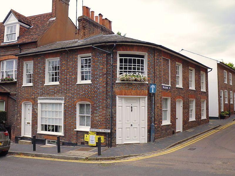
TL 1407 SW 8/52
1582
FISHPOOL STREET (North Side),
Nos 2 and 4
II
Early C19. Angle house built round corner into Welclose Street. 2 storeys,
3 windows on each return. On angle, 1st floor curved window and ground floor
street door with flanking panels. Red brick with diaper of blue headers.
Low pitched, hipped, slate roof. On 1st floor gauged, flat, red brick
arches to sash windows with glazing bars in stucco lined reveals. (3 of
these are blocked). Windows and doors on ground floor alternate between
elliptical and square heads with gauged, brick arches. Ground floor of No 4
has early C19 type of shop window.
Listing NGR: TL1437107209
External links are from the relevant listing authority and, where applicable, Wikidata. Wikidata IDs may be related buildings as well as this specific building. If you want to add or update a link, you will need to do so by editing the Wikidata entry.


Other nearby listed buildings
