Approximate Location Map
Large Map »
Latitude: 53.7361 / 53°44'10"N
Longitude: -0.5452 / 0°32'42"W
OS Eastings: 496060
OS Northings: 427618
OS Grid: SE960276
Mapcode National: GBR STM7.RF
Mapcode Global: WHGFN.LCL5
Plus Code: 9C5XPFP3+CW
Entry Name: Mill House
Listing Date: 3 March 1988
Grade: II
Source: Historic England
Source ID: 1103335
English Heritage Legacy ID: 164833
ID on this website: 101103335
Location: Welton, East Riding of Yorkshire, HU15
County: East Riding of Yorkshire
Civil Parish: Welton
Built-Up Area: Brough
Traditional County: Yorkshire
Lieutenancy Area (Ceremonial County): East Riding of Yorkshire
Church of England Parish: Welton St Helen
Church of England Diocese: York
Tagged with: House
WELTON DALE ROAD
SE 9627
(east side)
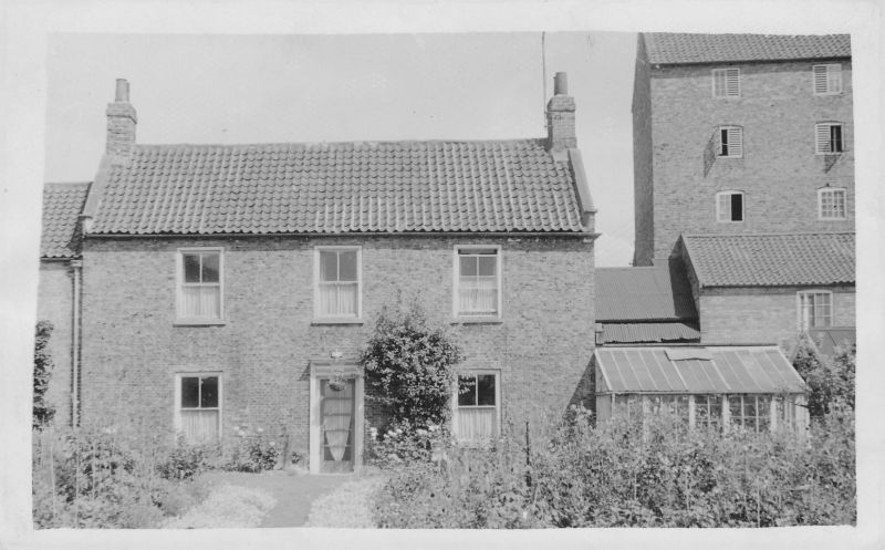
10/75 Mill House
GV II
House. Late C18. Red brick, stone dressings, pantiled roof. 2 storeys,
3 bays in symmetrical elevation. C20 glazed door in architrave with
pulvinated frieze incorporating central blank panel, and moulded cornice.
To right and to left are 4-pane sashes with sills. First floor: 3 similar
sashes. Cogged brick eaves cornice, end stacks, tumbled-in brick to raised
coped gables with brick kneelers.
Listing NGR: SE9606027618
External links are from the relevant listing authority and, where applicable, Wikidata. Wikidata IDs may be related buildings as well as this specific building. If you want to add or update a link, you will need to do so by editing the Wikidata entry.


Other nearby listed buildings
