Approximate Location Map
Large Map »
Latitude: 51.6637 / 51°39'49"N
Longitude: -0.3512 / 0°21'4"W
OS Eastings: 514136
OS Northings: 197384
OS Grid: TQ141973
Mapcode National: GBR 5X.S5B
Mapcode Global: VHFSM.VFQZ
Plus Code: 9C3XMJ7X+FG
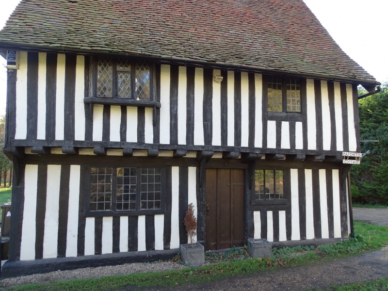
Entry Name: Patchetts
Listing Date: 15 March 1979
Grade: II
Source: Historic England
Source ID: 1103575
English Heritage Legacy ID: 164179
ID on this website: 101103575
Location: Patchetts Green, Hertsmere, Hertfordshire, WD25
County: Hertfordshire
District: Hertsmere
Electoral Ward/Division: Bushey North
Parish: Non Civil Parish
Built-Up Area: Bushey
Traditional County: Hertfordshire
Lieutenancy Area (Ceremonial County): Hertfordshire
Church of England Parish: Aldenham
Church of England Diocese: St.Albans
Tagged with: Building
TQ 19 NW BUSHEY HILFIELD LANE
(Southwest side)
Patchetts Green
6/131 Patchetts
15.3.79
GV II
House. Late C16, altered early C17, extended and altered in C19. Exposed
timber frame with brick additions. Tiled roof. 2 bays, originally part
of a larger building. 2 storeys. Old plank and muntin door with strap
hinges to right of centre. C17 2 and 3-light casements with leaded
panes. Close studding. Boldly jettied. First floor on brackets to right:
original timber diamond mullion and wide sill, left: small oriel on
brackets. Plinth. Steeply pitched roof. C19 ridge stack to right. Right
return - brick ground floor, first floor oriel on brackets, exposed
queen posts to collar clasping purlins. Catslide over rear outshut. To
rear left: C19 wing in stock brick possibly on site of original hall.
Main stack at junction of early block and C19 wing 2 rebuilt diagonal
tall red brick shafts, oversailing caps. Interior not inspected. (RCHM
Typescript: Herts Archaeology, vol.6, 1978, p.78).
Listing NGR: TQ1413697384
External links are from the relevant listing authority and, where applicable, Wikidata. Wikidata IDs may be related buildings as well as this specific building. If you want to add or update a link, you will need to do so by editing the Wikidata entry.


Other nearby listed buildings
