Approximate Location Map
Large Map »
Latitude: 52.4575 / 52°27'26"N
Longitude: -2.1474 / 2°8'50"W
OS Eastings: 390080
OS Northings: 284402
OS Grid: SO900844
Mapcode National: GBR 1BY.XKJ
Mapcode Global: VH91H.QHMG
Plus Code: 9C4VFV43+X2
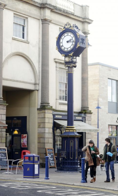
Entry Name: Clock Tower
Listing Date: 10 September 1971
Grade: II
Source: Historic England
Source ID: 1106310
English Heritage Legacy ID: 217863
ID on this website: 101106310
Location: Stourbridge, Dudley, West Midlands, DY8
County: Dudley
Electoral Ward/Division: Wollaston and Stourbridge Town
Parish: Non Civil Parish
Built-Up Area: Stourbridge
Traditional County: Worcestershire
Lieutenancy Area (Ceremonial County): West Midlands
Church of England Parish: Stourbridge St Thomas
Church of England Diocese: Worcester
Tagged with: Clock tower
1. MARKET STREET
1682 (West Side)
-----------
Clock Tower
SO 9084 1/47
II
2.
Late C19. Clock on cast iron fluted column.
Listing NGR: SO9008084402
External links are from the relevant listing authority and, where applicable, Wikidata. Wikidata IDs may be related buildings as well as this specific building. If you want to add or update a link, you will need to do so by editing the Wikidata entry.


Other nearby listed buildings
