Latitude: 52.34 / 52°20'24"N
Longitude: -1.5177 / 1°31'3"W
OS Eastings: 432953
OS Northings: 271438
OS Grid: SP329714
Mapcode National: GBR 6MZ.73Q
Mapcode Global: VHBXB.MFZZ
Plus Code: 9C4W8FRJ+2W
Entry Name: Stare Bridge
Listing Date: 11 April 1967
Grade: II*
Source: Historic England
Source ID: 1106390
English Heritage Legacy ID: 308191
ID on this website: 101106390
Location: Warwick, Warwickshire, CV8
County: Warwickshire
District: Warwick
Civil Parish: Stoneleigh
Built-Up Area: Stoneleigh Park
Traditional County: Warwickshire
Lieutenancy Area (Ceremonial County): Warwickshire
Church of England Parish: Stoneleigh St Mary the Virgin
Church of England Diocese: Coventry
Tagged with: Bridge Road bridge
STONELEIGH Stoneleigh Road
6/319 Stare Bridge
11.4.67
- II*
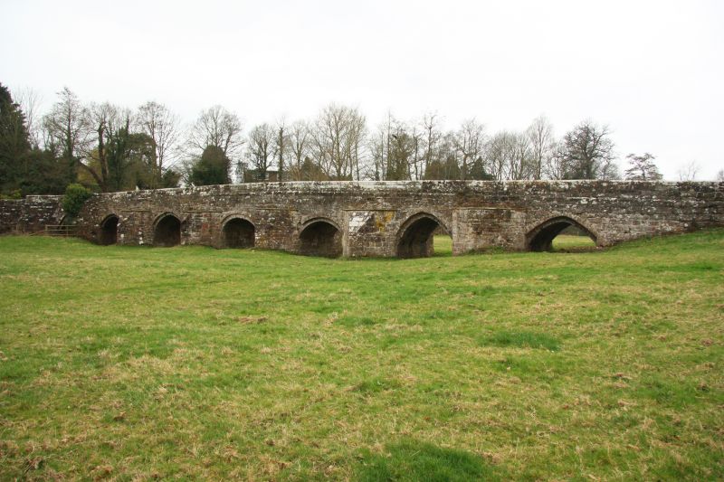
Late C15 long narrow bridge of 9 arches over the River Avon. Built for the
community of Stoneleigh Abbey. Red sandstone ashlar. 10 ft wide between plain
parapets. Slight camber. The river flows through the three southern arches,
the remainder acting as flood arches. On east side (upstream) the southern
three large cutwaters are carried up to form refuges. The remaining five
cutwaters on the east side have all been lowered to the level of the carriageway
and the parapet rebuilt straight. The five arches at the southern end are
pointed of two square orders, the next two are segmental, and the remaining two
are pointed. The west side of the bridge has no cutwaters and all the outer
arches have been rebuilt with buttresses of varying sizes added on each side of
them. The bridge is now disused being bypassed by a modern concrete structure
to the east. (Ancient Monument.)
Listing NGR: SP3295371438
External links are from the relevant listing authority and, where applicable, Wikidata. Wikidata IDs may be related buildings as well as this specific building. If you want to add or update a link, you will need to do so by editing the Wikidata entry.


Other nearby listed buildings