Approximate Location Map
Large Map »
Latitude: 50.8784 / 50°52'42"N
Longitude: -3.3476 / 3°20'51"W
OS Eastings: 305286
OS Northings: 109631
OS Grid: ST052096
Mapcode National: GBR LP.SZPS
Mapcode Global: FRA 36WS.7N1
Plus Code: 9C2RVMH2+9X
Entry Name: Front Range of Planned Farmyard Immediately South-East of Home Farmhouse
Listing Date: 15 April 1987
Grade: II
Source: Historic England
Source ID: 1106510
English Heritage Legacy ID: 95782
ID on this website: 101106510
Location: Mid Devon, EX15
County: Devon
District: Mid Devon
Civil Parish: Uffculme
Traditional County: Devon
Lieutenancy Area (Ceremonial County): Devon
Church of England Parish: Uffculme St Mary Virgin
Church of England Diocese: Exeter
Tagged with: Building
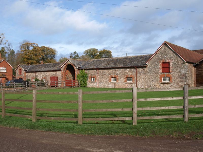
ST OO NE UFFCULME
8/127 Front range of planned
- farmyard immediately
south-east of Home Farmhouse
- II
Front range of the planned Home Farm to Bradfield House (q.v.) 1 building is dated
1862, and this probably dates the front range. Random rubble limestone with brick
dressing; gable end slate roof. A long low 2-storeyed range with a central tall
round-headed wagon entrance projecting slightly and separately gabled, surmounted by
a weather vane. 3 openings to either side of entrance, with a late C20 garage
entrance inserted to left-hand side. This range groups attractively with Home
Farmhouse (q.v.).
Listing NGR: ST0528609631
External links are from the relevant listing authority and, where applicable, Wikidata. Wikidata IDs may be related buildings as well as this specific building. If you want to add or update a link, you will need to do so by editing the Wikidata entry.


Other nearby listed buildings
