Latitude: 51.1005 / 51°6'1"N
Longitude: -4.1378 / 4°8'16"W
OS Eastings: 250414
OS Northings: 135645
OS Grid: SS504356
Mapcode National: GBR KM.BX64
Mapcode Global: VH4MQ.7LCP
Plus Code: 9C3Q4V26+6V
Entry Name: Eastacombe Farmhouse and Adjoining Granaries and Pump House
Listing Date: 25 February 1965
Last Amended: 14 January 1985
Grade: II
Source: Historic England
Source ID: 1107740
English Heritage Legacy ID: 98430
ID on this website: 101107740
Location: Heanton Punchardon, North Devon, EX31
County: Devon
District: North Devon
Civil Parish: Heanton Punchardon
Traditional County: Devon
Lieutenancy Area (Ceremonial County): Devon
Church of England Parish: Heanton Punchardon St Augustine
Church of England Diocese: Exeter
Tagged with: Farmhouse
HEANTON PUNCHARDON EASTACOMBE LANE, Heanton SS 53 NW Punchardon 8/181 Eastacombe Farmhouse and 25.2.65 adjoining granaries and Pump- House GV II
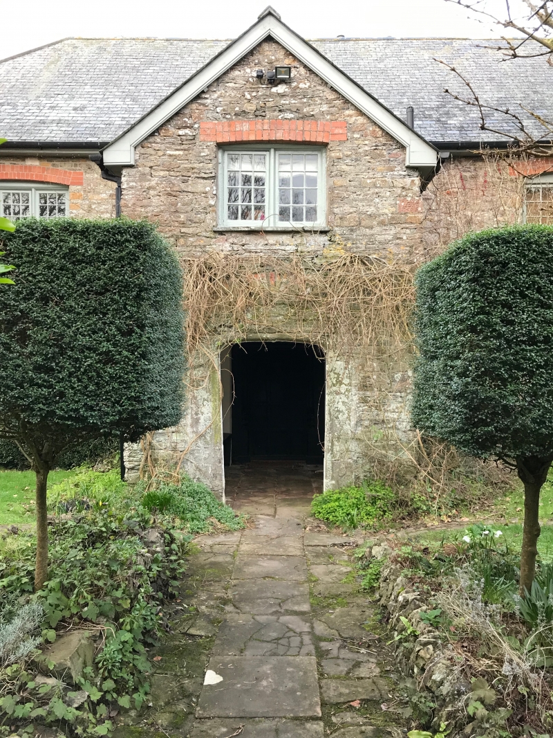
Farmhouse and adjoining granaries and pump-house. C16,possibly earlier core (1597 datestone in porch) partially refronted in C18 (1735 carved in right hand ground floor window jamb) and large C19 wing added to rear. Principally cob and shale faced in laced and dressed stone to left and squared rubble to right of cob porch cased in rubble. Slate roof, hipped at left end, gable-ended to right. Single room each side of central passage with 2-storey gable-ended porch to front and projecting stair turret to rear, also gable-ended. Outshut added in the angle to east with lean-to slate roof and right-angled long extension to rear left end forming L-shape plan to dwelling, further extended northwards with granaries and outbuildings projecting eastwards to complete overall 3-side courtyard plan. Brick stack at right gable end of main range and lateral stack to rear of cell to left now encased in extension. 2 storey, 3 window range. 2- storey gabled porch almost at centre with 2-light casement with 12 panes each light over stone roll-moulded porch doorway possibly reset with depressed Tudor arch with plain spandrels. Datestone near wallheight top right of front with inscription :F 20 B 1597 E 40 R. Fine Cl7 inner doorway, square-headed with chamfered surround and heavily carved ornamentation near the base of the jambs. Ancient framed and ledged door of 3 wide planks with cover strips and square-headed nails. To either side of porch, C20 3-light timber casements on each floor in altered window openings with cambered brick arches, that at top left retaining C18/19 12-paned casements. L 11 1735 carved in right hand ground floor window jamb. Further inverted stone at wall-height near right end initialled GLELRL. At right gable end, 2-light above single light window in slight narrow 2-storey projection accommodating garderobe. Rear C19 wing has 2 axial brick stacks and 3-window range of sashes 8 panes over 8 panes on each floor with flat brick arches. Granaries extend northwards then at right angles to east with hipped end to slate roof and external stone steps to 2 plank doors with loft door to right. 2 plank doors below with brick arches. Single-storey rubble extension to right with slate roof and central opening. Adjoining east end of granary and projecting into courtyard is small rectangular pump-house with hipped slate roof, open to front and north side. In main range, much of the internal joinery is intact with stopped and chamfered door frames to majority of rooms, early doors to principal cell to left of passage and to upper storey of porch. Winder staircase with moulded handrail and square newels with stick balusters to first flight only. Roof not inspected.
Listing NGR: SS5041435645
External links are from the relevant listing authority and, where applicable, Wikidata. Wikidata IDs may be related buildings as well as this specific building. If you want to add or update a link, you will need to do so by editing the Wikidata entry.


Other nearby listed buildings