Approximate Location Map
Large Map »
Latitude: 50.3704 / 50°22'13"N
Longitude: -3.5167 / 3°31'0"W
OS Eastings: 292236
OS Northings: 53382
OS Grid: SX922533
Mapcode National: GBR QX.922Z
Mapcode Global: FRA 38J2.1SQ
Plus Code: 9C2R9FCM+58
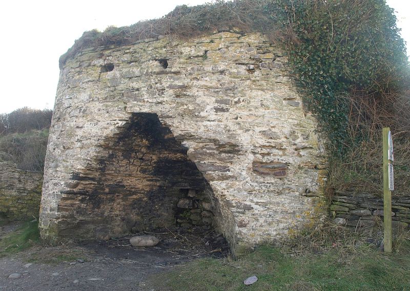
Entry Name: Limekiln Approximately 70 Metres North of Coastguard Cottages
Listing Date: 21 May 1985
Grade: II
Source: Historic England
Source ID: 1108553
English Heritage Legacy ID: 100591
ID on this website: 101108553
Location: Southdown, South Hams, Devon, TQ6
County: Devon
District: South Hams
Civil Parish: Kingswear
Traditional County: Devon
Lieutenancy Area (Ceremonial County): Devon
Church of England Parish: Brixham St Mary
Church of England Diocese: Exeter
Tagged with: Lime kiln
SX 95 SW KINGSWEAR WOODHUISH LANE
10/44 Limekiln approximately
70 metres north of
- coastguard cottages
- II
Limekiln. Circa early C19. Stone rubble structure built into bank on south edge
of Man Sands (a beach). Rounded corners and almost flat front with nearly
pointed head to kiln opening on front.
Listing NGR: SX9223653382
External links are from the relevant listing authority and, where applicable, Wikidata. Wikidata IDs may be related buildings as well as this specific building. If you want to add or update a link, you will need to do so by editing the Wikidata entry.


Other nearby listed buildings
