Approximate Location Map
Large Map »
Latitude: 53.0168 / 53°1'0"N
Longitude: -1.7343 / 1°44'3"W
OS Eastings: 417919
OS Northings: 346639
OS Grid: SK179466
Mapcode National: GBR 48Q.SFF
Mapcode Global: WHCF5.BFCM
Plus Code: 9C5W2788+P7
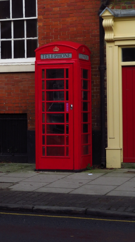
Entry Name: K6 Telephone Kiosk
Listing Date: 15 April 1988
Grade: II
Source: Historic England
Source ID: 1109467
English Heritage Legacy ID: 79947
ID on this website: 101109467
Location: Bellevue, Derbyshire Dales, Derbyshire, DE6
County: Derbyshire
District: Derbyshire Dales
Civil Parish: Ashbourne
Built-Up Area: Ashbourne
Traditional County: Derbyshire
Lieutenancy Area (Ceremonial County): Derbyshire
Church of England Parish: Ashbourne St Oswald
Church of England Diocese: Derby
Tagged with: K6 telephone box
CHURCH STREET
SK 17 46
(north side)
1/3A
II K6 Telephone Kiosk
GV
Telephone kiosk. Type K6. Designed 1935 by Sir Giles Gilbert Scott. Made by
various contractors. Cast iron. Square kiosk with domed roof. Unperforated
crowns to top panels and margin glazing to windows and door.
Listing NGR: SK1791946639
External links are from the relevant listing authority and, where applicable, Wikidata. Wikidata IDs may be related buildings as well as this specific building. If you want to add or update a link, you will need to do so by editing the Wikidata entry.


Other nearby listed buildings
