Approximate Location Map
Large Map »
Latitude: 53.0174 / 53°1'2"N
Longitude: -1.7323 / 1°43'56"W
OS Eastings: 418058
OS Northings: 346710
OS Grid: SK180467
Mapcode National: GBR 48Q.T09
Mapcode Global: WHCF5.CFC4
Plus Code: 9C5W2789+X3
Entry Name: 22, St John's Street
Listing Date: 14 February 1974
Grade: II
Source: Historic England
Source ID: 1109500
English Heritage Legacy ID: 79913
ID on this website: 101109500
Location: Ashbourne, Derbyshire Dales, Derbyshire, DE6
County: Derbyshire
District: Derbyshire Dales
Civil Parish: Ashbourne
Built-Up Area: Ashbourne
Traditional County: Derbyshire
Lieutenancy Area (Ceremonial County): Derbyshire
Church of England Parish: Ashbourne St Oswald
Church of England Diocese: Derby
Tagged with: Building
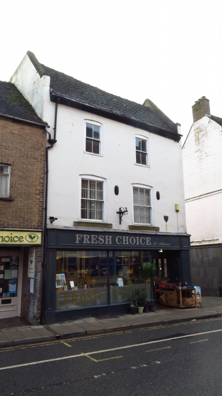
ST JOHN'S STREET
1.
783
(South-East Side)
No 22
SK 14 NE 1/164
II GV
2.
C18. Double span house. Rendered, old tiled roof with gabled ends - the northern
one truncated 3 storeys, 2 windows with boxed frames. Those of 1st floor with
glazing bars. Modern shop front.
No 2 and 6 to 44 (even) form a group.
Listing NGR: SK1805846710
External links are from the relevant listing authority and, where applicable, Wikidata. Wikidata IDs may be related buildings as well as this specific building. If you want to add or update a link, you will need to do so by editing the Wikidata entry.


Other nearby listed buildings
