Approximate Location Map
Large Map »
Latitude: 53.0167 / 53°1'0"N
Longitude: -1.7332 / 1°43'59"W
OS Eastings: 417996
OS Northings: 346630
OS Grid: SK179466
Mapcode National: GBR 48Q.SRS
Mapcode Global: WHCF5.BFXP
Plus Code: 9C5W2788+MP
Entry Name: 13, Dig Street
Listing Date: 14 February 1974
Last Amended: 30 July 1991
Grade: II
Source: Historic England
Source ID: 1109518
English Heritage Legacy ID: 79861
ID on this website: 101109518
Location: Ashbourne, Derbyshire Dales, Derbyshire, DE6
County: Derbyshire
District: Derbyshire Dales
Civil Parish: Ashbourne
Built-Up Area: Ashbourne
Traditional County: Derbyshire
Lieutenancy Area (Ceremonial County): Derbyshire
Church of England Parish: Ashbourne St Oswald
Church of England Diocese: Derby
Tagged with: Building
In the entry for the following:
DIG STREET
1.
783 (South-West Side)
Nos 13 & 15
SK 14 NE 1/63
II GV
The address shall be amended to read:
1. DIG STREET
783 (South-West Side)
No. 13
SK 14 NE 1/63
II GV
And the description shall be amended to read:
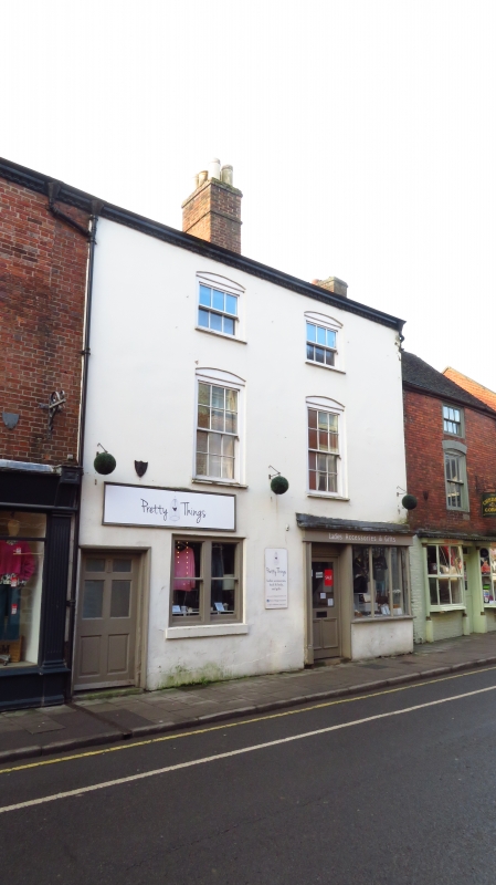
House with shop. Circa 1800. Stuccoed brick, tiled roof. 3
storeys. Regular 2-window range. Dentil cornice. Moulded
surrounds to 1st and 2nd floor windows, the former with 12-pane
the latter with 6-pane hornless sash windows. Wide doorway with
raised panelled door to left divided by 2-light sash window from
mid-late C19 shop front which returns to right, with end panelled
pilasters and panelled door under rectangular overlight. Ridge
stacks. 2-light casements to rear.
------------------------------------
DIG STREET
1.
783
(South-West Side)
Nos 13 & 15
SK 14 NE 1/63
II GV
2.
C18. Red brick with tiled roof. 3 storeys, 5 windows. No 13 is stuccoed. Modern
shop fronts.
Nos 9 to 17 (odd) form a group.
Listing NGR: SK1799646630
External links are from the relevant listing authority and, where applicable, Wikidata. Wikidata IDs may be related buildings as well as this specific building. If you want to add or update a link, you will need to do so by editing the Wikidata entry.


Other nearby listed buildings
