Latitude: 53.083 / 53°4'58"N
Longitude: -1.5739 / 1°34'26"W
OS Eastings: 428637
OS Northings: 354055
OS Grid: SK286540
Mapcode National: GBR 59G.QX6
Mapcode Global: WHCDV.SRPX
Plus Code: 9C5W3CMG+5C
Entry Name: 1-3, Green Hill
Listing Date: 23 January 1973
Grade: II
Source: Historic England
Source ID: 1109582
English Heritage Legacy ID: 79716
ID on this website: 101109582
Location: Wirksworth, Derbyshire Dales, Derbyshire, DE4
County: Derbyshire
District: Derbyshire Dales
Civil Parish: Wirksworth
Built-Up Area: Wirksworth
Traditional County: Derbyshire
Lieutenancy Area (Ceremonial County): Derbyshire
Church of England Parish: Wirksworth St Mary
Church of England Diocese: Derby
Tagged with: Building
GREEN HILL 1. 1839 Nos 1 to 3 (consec) (Formerly listed under Dale End) SK 2854 1/19 24.10.50.
II
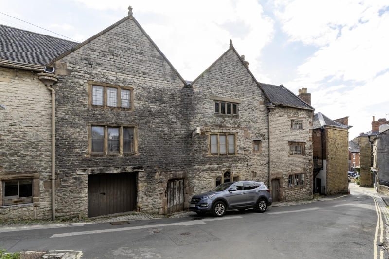
2. Circa 1630. Coursed stone rubble; 2 storeys and attics; mullioned windows throughout, entirely unglazed and boarded up or defaced; 2 chamfered square- headed doorways; 2 gables and stone gable at south end, formerly with obelisk finials. A massive range, now roofless and derelict.
Listing NGR: SK2863754055
External links are from the relevant listing authority and, where applicable, Wikidata. Wikidata IDs may be related buildings as well as this specific building. If you want to add or update a link, you will need to do so by editing the Wikidata entry.


Other nearby listed buildings