Approximate Location Map
Large Map »
Latitude: 52.9378 / 52°56'16"N
Longitude: -1.8021 / 1°48'7"W
OS Eastings: 413395
OS Northings: 337840
OS Grid: SK133378
Mapcode National: GBR 49L.TF4
Mapcode Global: WHCFJ.9F25
Plus Code: 9C4WW5QX+44
Entry Name: The Manor House
Listing Date: 5 February 1952
Grade: II*
Source: Historic England
Source ID: 1109755
English Heritage Legacy ID: 81283
ID on this website: 101109755
Location: Marston Montgomery, Derbyshire Dales, Derbyshire, DE6
County: Derbyshire
District: Derbyshire Dales
Civil Parish: Marston Montgomery
Traditional County: Derbyshire
Lieutenancy Area (Ceremonial County): Derbyshire
Church of England Parish: Marston Montgomery St Giles
Church of England Diocese: Derby
Tagged with: House
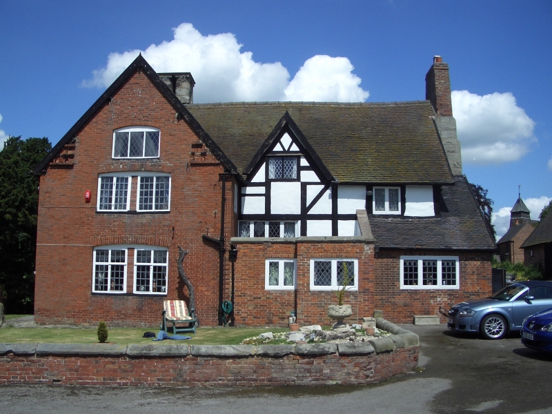
SK 13 NW PARISH OF MARSTON MONTGOMERY MAIN STREET
4/53 (South side)
5.2.52 The Manor House
II*
House. Late C17 with C19 and C20 alterations and additions. Box timber framing on
stone plinth with painted brick nogging and brick with brick dressings. Plain tile
roofs with large stone ridge stack, topped by four circular stone pots, to west and
enormous stepped external stone stack to east gable wall, topped by brick extension.
Two storeys plus garrets and two bay east wing with advanced single bay crosswing.
North elevation has 4-light leaded casement window in western crosswing and similar
window to.east of east range, and between has been inserted a large two storey brick
bay with bowed front. This has C20 5-light leaded casement window in bowed end and
a panelled door with bracketed hood over to east side. Above, similar windows in same
arrangement. Above again to west, a jettied gabled on carved timber brackets with
blocked window to top. To east, projecting from the roof over the later brick bay is
an advanced gabled timber frame bay, probably the former porch,and beyond to east, a
gabled roof dormer with leaded lights to top and box framing below. South elevation
has crosswing rebuilt in brick and ground floor hidden by C20 brick extensions.
Interior has virtually all its original timber frame exposed, and chamfered ceiling
beams. South room of crosswing has C17 panelling, carved fireplace and overmantle
dated 1670 and panelled corner with shaped all possibly re-used, Original dogleg
staircase through three floors with shaped splat balusters and moulded finials.
West rooms of crosswing have stone four-centred arched fireplaces, that to first
floor with carved spandrels.
Listing NGR: SK1339537840
External links are from the relevant listing authority and, where applicable, Wikidata. Wikidata IDs may be related buildings as well as this specific building. If you want to add or update a link, you will need to do so by editing the Wikidata entry.


Other nearby listed buildings
