Approximate Location Map
Large Map »
Latitude: 51.0262 / 51°1'34"N
Longitude: -2.2166 / 2°12'59"W
OS Eastings: 384908
OS Northings: 125224
OS Grid: ST849252
Mapcode National: GBR 1X8.QD3
Mapcode Global: FRA 667D.Q95
Plus Code: 9C3V2QGM+F9
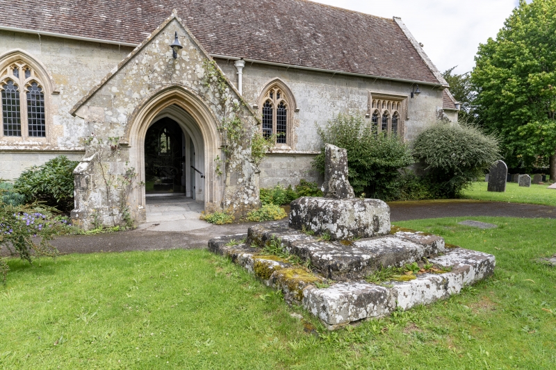
Entry Name: Churchyard Cross Approximately 2M South of Porch of Church of St Mary
Listing Date: 3 January 1985
Grade: II
Source: Historic England
Source ID: 1110289
English Heritage Legacy ID: 103051
ID on this website: 101110289
Location: Motcombe, Dorset, SP7
County: Dorset
Civil Parish: Motcombe
Built-Up Area: Motcombe
Traditional County: Dorset
Lieutenancy Area (Ceremonial County): Dorset
Church of England Parish: Motcombe St Mary
Church of England Diocese: Salisbury
Tagged with: Churchyard cross
ST 82 NW MOTCOMBE MOTCOMBE VILLAGE
3/210 Churchyard cross
approximately 2m
south of porch of
Church of St Mary
GV II
Base of cross, C15. Stone. Stump of octagonal shaft with run-out
stops on square base block. The whole is on 2 step base.
Listing NGR: ST8490825224
External links are from the relevant listing authority and, where applicable, Wikidata. Wikidata IDs may be related buildings as well as this specific building. If you want to add or update a link, you will need to do so by editing the Wikidata entry.


Other nearby listed buildings
