Approximate Location Map
Large Map »
Latitude: 51.0384 / 51°2'18"N
Longitude: -2.2933 / 2°17'35"W
OS Eastings: 379532
OS Northings: 126596
OS Grid: ST795265
Mapcode National: GBR 0VN.WHS
Mapcode Global: FRA 662C.QDQ
Plus Code: 9C3V2PQ4+8M
Entry Name: Brewery House and Front Fence
Listing Date: 8 December 1975
Grade: II
Source: Historic England
Source ID: 1110308
English Heritage Legacy ID: 102992
ID on this website: 101110308
Location: Wyke, Dorset, SP8
County: Dorset
Civil Parish: Gillingham
Built-Up Area: Gillingham
Traditional County: Dorset
Lieutenancy Area (Ceremonial County): Dorset
Church of England Parish: Gillingham St Mary the Virgin
Church of England Diocese: Salisbury
Tagged with: Brewery
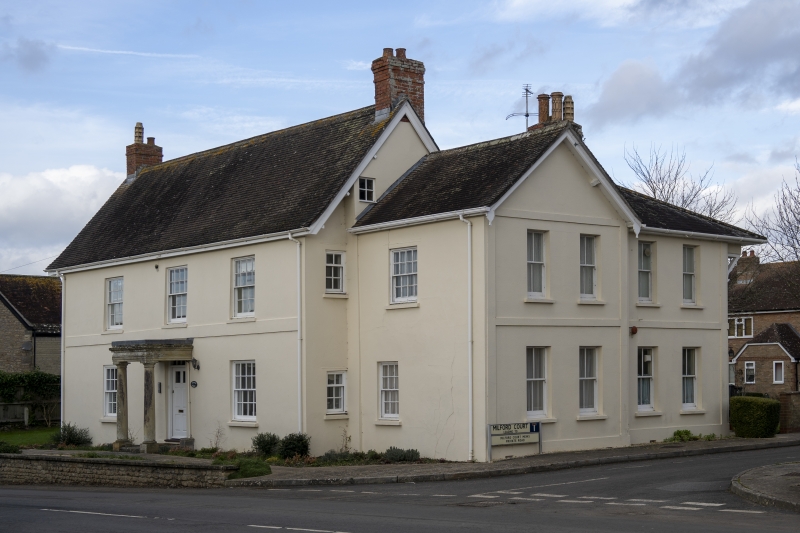
ST 72 NE GILLINGHAM WYKE
2/153 Brewery House and
front fence
8.12.75.
- II
GV
House, probably late C18. Rendered with gable-ended tiled roof and
end brick stacks. Symmetrical. 2 storeys, 3 bay. 16-pane sashes.
Flat porch supported on Tuscan columns. Part-glazed, panelled floor.
Cast-iron fence and gates to front.
(RCHM, Dorset, vol IV, p 33, no 61).
Listing NGR: ST7953226596
External links are from the relevant listing authority and, where applicable, Wikidata. Wikidata IDs may be related buildings as well as this specific building. If you want to add or update a link, you will need to do so by editing the Wikidata entry.


Other nearby listed buildings
