Latitude: 51.201 / 51°12'3"N
Longitude: 0.2772 / 0°16'37"E
OS Eastings: 559189
OS Northings: 147103
OS Grid: TQ591471
Mapcode National: GBR MP0.QWR
Mapcode Global: VHHQ6.R2DN
Plus Code: 9F32672G+9V
Entry Name: 3, Shipbourne Road
Listing Date: 20 January 1972
Grade: II
Source: Historic England
Source ID: 1111898
English Heritage Legacy ID: 178731
ID on this website: 101111898
Location: The Park, Tonbridge and Malling, Kent, TN10
County: Kent
District: Tonbridge and Malling
Electoral Ward/Division: Castle
Parish: Non Civil Parish
Built-Up Area: Tonbridge
Traditional County: Kent
Lieutenancy Area (Ceremonial County): Kent
Church of England Parish: Tonbridge St Peter and St Paul
Church of England Diocese: Rochester
Tagged with: Building
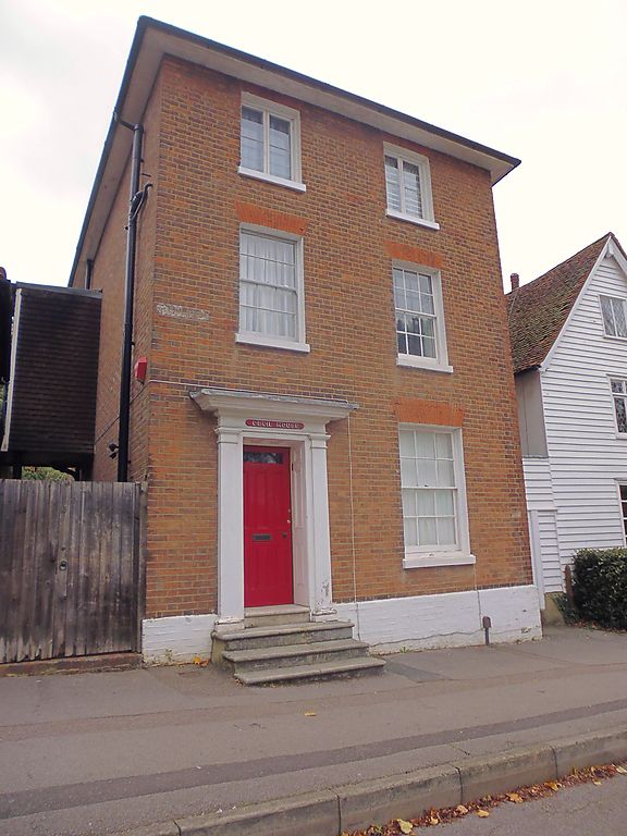
1. SHIPBOURNE ROAD
1732 (East Side)
TQ 5947 SW 5/65 No 3
II
2.
Late C18 house, 3 storeys, 2 windows in red brick. Plain flat pedimented door
case on left hand side. 7 fielded door of which upper panel is glass filled.
Glazing bars intact except second floor which has casements. Hipped slate roof.
Listing NGR: TQ5918947103
External links are from the relevant listing authority and, where applicable, Wikidata. Wikidata IDs may be related buildings as well as this specific building. If you want to add or update a link, you will need to do so by editing the Wikidata entry.


Other nearby listed buildings