Approximate Location Map
Large Map »
Latitude: 51.4566 / 51°27'23"N
Longitude: -0.9716 / 0°58'17"W
OS Eastings: 471547
OS Northings: 173572
OS Grid: SU715735
Mapcode National: GBR QLF.V8
Mapcode Global: VHDWT.3NP6
Plus Code: 9C3XF24H+J9
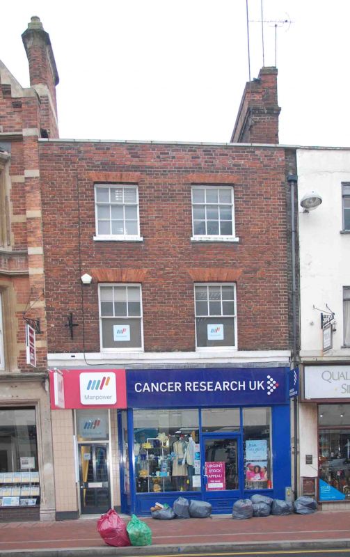
Entry Name: 154, Friar Street
Listing Date: 14 December 1978
Grade: II
Source: Historic England
Source ID: 1113489
English Heritage Legacy ID: 38959
ID on this website: 101113489
Location: Reading, Berkshire, RG1
County: Reading
Electoral Ward/Division: Abbey
Parish: Non Civil Parish
Built-Up Area: Reading
Traditional County: Berkshire
Lieutenancy Area (Ceremonial County): Berkshire
Church of England Parish: Reading St Mary the Virgin
Church of England Diocese: Oxford
Tagged with: Building
1.
5128
SU 7173 NE
1/428
FRIAR STREET
(South Side)
No 154
II
2.
Formerly a pair with No 153 (too altered to include). Circa 1800. 3 storeys,
red brick with stone cills to 1st floor and stone coping to parapet. 2 ranges
of glazing bar sashes. Modern shop front.
Listing NGR: SU7154773572
External links are from the relevant listing authority and, where applicable, Wikidata. Wikidata IDs may be related buildings as well as this specific building. If you want to add or update a link, you will need to do so by editing the Wikidata entry.


Other nearby listed buildings
