History in Structure

103 London Street

A Grade II Listed Building in Katesgrove, Reading

More Photos »
Approximate Location Map
Large Map »

Coordinates

Latitude: 51.4511 / 51°27'3"N

Longitude: -0.9672 / 0°58'1"W

OS Eastings: 471862

OS Northings: 172962

OS Grid: SU718729

Mapcode National: GBR QMH.T8

Mapcode Global: VHDWT.6S0G

Plus Code: 9C3XF22M+C4
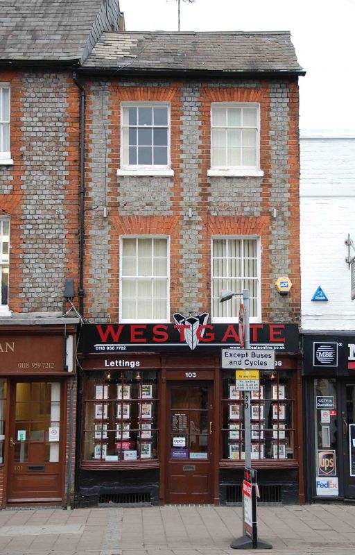
Entry Name: 103 London Street

Listing Date: 22 March 1957

Last Amended: 5 March 2024

Grade: II

Source: Historic England

Source ID: 1113520

English Heritage Legacy ID: 39039

ID on this website: 101113520

Location: Reading, Berkshire, RG1

County: Reading

Electoral Ward/Division: Katesgrove

Parish: Non Civil Parish

Built-Up Area: Reading

Traditional County: Berkshire

Lieutenancy Area (Ceremonial County): Berkshire

Church of England Parish: Reading St Giles

Church of England Diocese: Oxford

Tagged with: Building

Find accommodation in
Caversham

Summary


House with shopfront, constructed in the early C19. Later C20 rear extensions.

Description


House with shopfront, constructed in the early C19. Later C20 rear extensions.

MATERIALS: built of silver-grey brick headers with red-brick dressings. Slate roof covering.

PLAN: the building comprises a three storey plus basement, rectangular range fronting London Street to the west with C20 single-storey extensions to the rear.

EXTERIOR: the ground floor has an early-C19 (possibly original) shopfront with two bows flanking a central, half-glazed and panelled doorway. The bows each contain a twelve-pane window with glazing bars, topped by a frieze and moulded cornice which extends above the door with narrow pilaster strips. The bows are supported on narrow iron brackets, below which are metal grilles to the basement.

The first and second floors are composed of grey header-bond brickwork with redbrick quoins and window dressings. There are two bays of timber sash windows at first- and second-floor levels; the first-floor windows have six-over-six glazing, while the second floor contains three-over-six glazing. Over each window is a gauged red brick lintel.

The building has a pitched roof with east-west orientated slopes. The rear of the building is concealed by C20 single-storey extensions.

INTERIOR: it is understood that there is a staircase with cast-iron baluster standards.

History


The first written record of Reading dates from the ninth century when the name seems to have referred to a tribe, called Reada’s people. It is possible that there was a river port here during the Roman occupation, and by 1086 there was a thriving urban community, recorded in the Domesday Book. The early Anglo-Saxon settlement is believed to have been located in the Castle Street and St Mary’s area, which has St Mary’s Minster at its heart.

Reading Abbey was founded in 1121 on a site to the north-east of the core of the Saxon town and this transformed Reading into a place of pilgrimage as well as an important trading and ecclesiastical centre with one of the biggest and richest monasteries in England.

A new bridge over the River Kennet had been built by 1186 and London Street was laid out with plots of land as part of the Abbot of Reading Abbey’s urban planning vision. The aim was to divert trade and traffic to the new marketplace at the gates of the Abbey. The transition from the old marketplace at St Mary's Butts was at first resisted by the merchants of Reading but the move was complete by the C14. The dissolution of the Abbey led to the monastic complex becoming a royal palace and by 1611 the town’s population had grown to over 5,000 as a result of its cloth trade John Speed’s map shows that by 1611, both sides of London Street had been developed with continuous frontages for a considerable distance southward, beyond the modern junction with Crown Street-London Road, with long gardens, outhouses and fields beyond. Several buildings which predate Speed’s map survive on London Street, some concealed behind later, brick façades. Following significant upheaval during the Civil War, the town flourished during the C18 and C19, and the survival of many fine Georgian and Victorian buildings which characterise London Street, testifies to the prosperity of the street during this period.

103 London Street was built in the early C19, likely replacing an earlier building. The Reading Board of Health Map (1853) shows how at that time the building consisted of a principal street-facing (west) range and a rear (eastern) extension which backed onto a small, narrow garden. Later rear extensions in the C20 eventually entirely subsumed the eastern part of the plot.

Reasons for Listing


103 London Street is listed at Grade II for the following principal reasons:

Architectural interest:

*     as an early-C19 townhouse that contributes to the character of an architecturally varied historic streetscape.

Historic interest:

*     as part of the urban development of Reading’s ancient core.

Group value:

*    the building is in close proximity to a large number of listed buildings and forms part of a strong historic grouping.

External Links

External links are from the relevant listing authority and, where applicable, Wikidata. Wikidata IDs may be related buildings as well as this specific building. If you want to add or update a link, you will need to do so by editing the Wikidata entry.

Recommended Books

Other nearby listed buildings

BritishListedBuildings.co.uk is an independent online resource and is not associated with any government department. All government data published here is used under licence. Please do not contact BritishListedBuildings.co.uk for any queries related to any individual listed building, planning permission related to listed buildings or the listing process itself.

British Listed Buildings is a Good Stuff website.