Latitude: 52.1939 / 52°11'37"N
Longitude: -0.5129 / 0°30'46"W
OS Eastings: 501744
OS Northings: 256112
OS Grid: TL017561
Mapcode National: GBR G1B.H4M
Mapcode Global: VHFQ1.2460
Plus Code: 9C4X5FVP+GR
Entry Name: 7, Rushden Road
Listing Date: 27 August 1987
Grade: II
Source: Historic England
Source ID: 1114306
English Heritage Legacy ID: 37034
ID on this website: 101114306
Location: Milton Ernest, Bedford, Bedfordshire, MK44
County: Bedford
Civil Parish: Milton Ernest
Built-Up Area: Milton Ernest
Traditional County: Bedfordshire
Lieutenancy Area (Ceremonial County): Bedfordshire
Church of England Parish: Milton Ernest
Church of England Diocese: St.Albans
Tagged with: Building
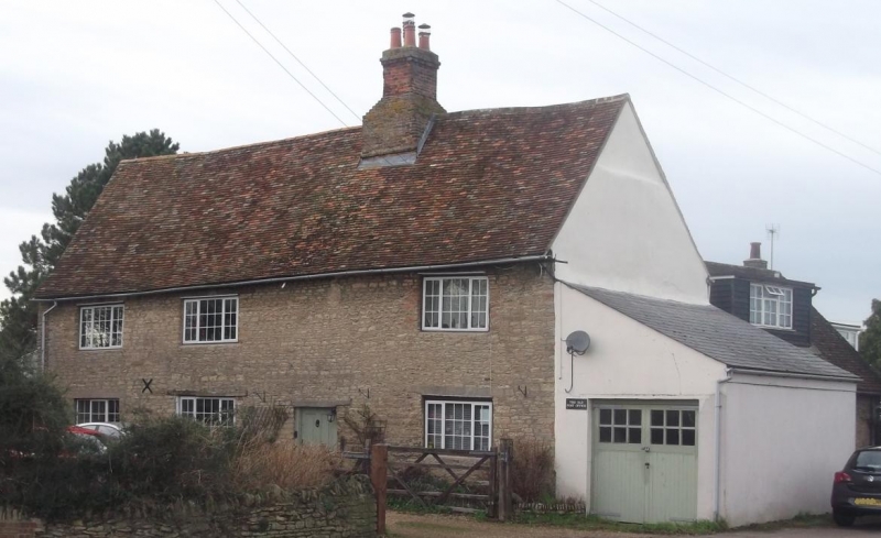
MILTON ERNEST RUSHDEN ROAD
TL 0156
23/264 No. 7
-
- II
Large C17 farmhouse. Coursed limestone rubble, old clay tile roof,
substantial brick stack. Three room plan with back-to-back hearth, side
opposite front entrance. Front elevation has three modern windows to each of
two storeys. Four panelled front door.
Listing NGR: TL0174456112
External links are from the relevant listing authority and, where applicable, Wikidata. Wikidata IDs may be related buildings as well as this specific building. If you want to add or update a link, you will need to do so by editing the Wikidata entry.


Other nearby listed buildings