Approximate Location Map
Large Map »
Latitude: 51.9053 / 51°54'19"N
Longitude: -0.5154 / 0°30'55"W
OS Eastings: 502231
OS Northings: 224018
OS Grid: TL022240
Mapcode National: GBR G4T.GJ0
Mapcode Global: VHFRD.0CWQ
Plus Code: 9C3XWF4M+4R
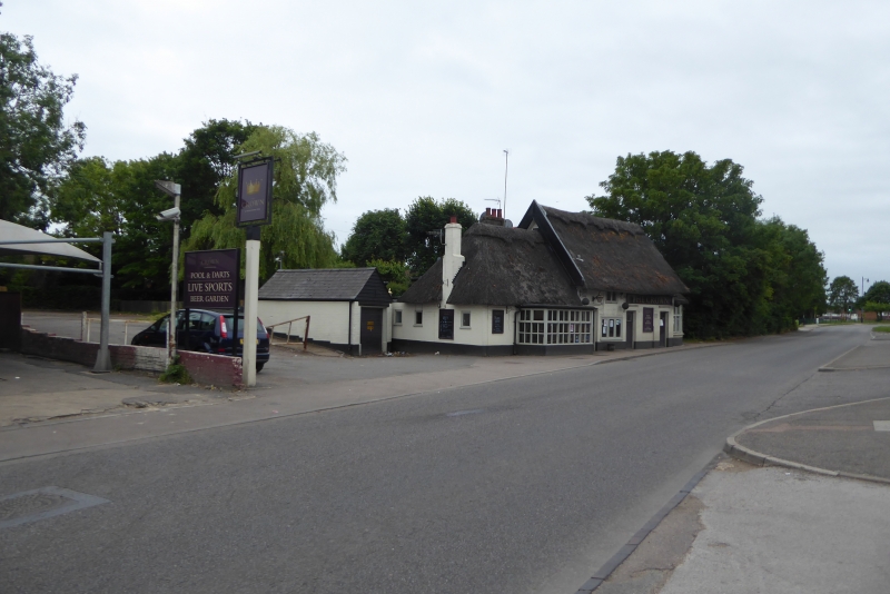
Entry Name: The Crown Public House
Listing Date: 26 September 1980
Grade: II
Source: Historic England
Source ID: 1114705
English Heritage Legacy ID: 36008
Also known as: The Crown, Houghton Regis
ID on this website: 101114705
Location: Houghton Regis, Central Bedfordshire, LU5
County: Central Bedfordshire
Civil Parish: Houghton Regis
Built-Up Area: Houghton Regis
Traditional County: Bedfordshire
Lieutenancy Area (Ceremonial County): Bedfordshire
Church of England Parish: Houghton Regis
Church of England Diocese: St.Albans
Tagged with: Pub
1.
5125 HOUGHTON REGIS THE GREEN
(north side)
The Crown Public House
TL 02 SW 38/184
II
2.
C17. Whitewashed brick front. Two storeys. Thatched. One casement window with
glazing bars; all other windows and doors modern. One storey thatched extension
to both gable ends.
Listing NGR: TL0223124018
External links are from the relevant listing authority and, where applicable, Wikidata. Wikidata IDs may be related buildings as well as this specific building. If you want to add or update a link, you will need to do so by editing the Wikidata entry.


Other nearby listed buildings
