Latitude: 51.4615 / 51°27'41"N
Longitude: -2.3169 / 2°19'0"W
OS Eastings: 378080
OS Northings: 173661
OS Grid: ST780736
Mapcode National: GBR 0PL.91S
Mapcode Global: VH967.SJHG
Plus Code: 9C3VFM6M+H6
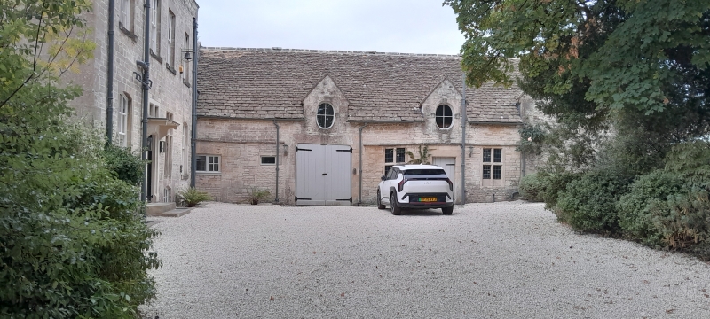
Entry Name: Stables and Coach House Barn, Stables and Pigsties Adjoining and to North of Marshfield House
Listing Date: 17 September 1952
Last Amended: 10 November 1983
Grade: II
Source: Historic England
Source ID: 1114948
English Heritage Legacy ID: 34573
ID on this website: 101114948
Location: Marshfield, South Gloucestershire, SN14
County: South Gloucestershire
Civil Parish: Marshfield
Built-Up Area: Marshfield
Traditional County: Gloucestershire
Lieutenancy Area (Ceremonial County): Gloucestershire
Church of England Parish: Marshfield
Church of England Diocese: Bristol
Tagged with: Stable
MARSHFIELD C.P. MARKET PLACE (west side) ST 7873 14/160 Stables and Coach House Barn, stables and pigsties 17.9.52 (formerly listed as Stables and Barn) G.V. adjoining and to north of Marshfield House
II
Stables, coach house, barn and outbuildings. Stables and coach house late C17; barn and outbuildings late C18/early C19. Stables and coach houses;coursed rubble; Cotswold stone slate roof; single storey and loft in 2 coped stone gables with saddle stones; 2 cross windows under continuous string course; carriage entry to left with flat segmental head and keystone; large keyed oval windows in gables. Barn: rubble; Cotswold tone slate roof; 5 bays, Queen post truss roof; square headed carriage entry to north. To the north-west of the barn are 2 attached stables: rubble, pantile roof; 2 plank doors with lattice heads; low pigsty adjoining.
Listing NGR: ST7808073661
External links are from the relevant listing authority and, where applicable, Wikidata. Wikidata IDs may be related buildings as well as this specific building. If you want to add or update a link, you will need to do so by editing the Wikidata entry.


Other nearby listed buildings