Approximate Location Map
Large Map »
Latitude: 51.3987 / 51°23'55"N
Longitude: -2.2939 / 2°17'37"W
OS Eastings: 379651
OS Northings: 166665
OS Grid: ST796666
Mapcode National: GBR 0QD.8VN
Mapcode Global: VH96N.635M
Plus Code: 9C3V9PX4+FC
Entry Name: 142, High Street
Listing Date: 19 October 1983
Grade: II
Source: Historic England
Source ID: 1115290
English Heritage Legacy ID: 32249
ID on this website: 101115290
Location: Bathford, Bath and North East Somerset, Somerset, BA1
County: Bath and North East Somerset
Civil Parish: Bathford
Built-Up Area: Bath
Traditional County: Somerset
Lieutenancy Area (Ceremonial County): Somerset
Tagged with: Building
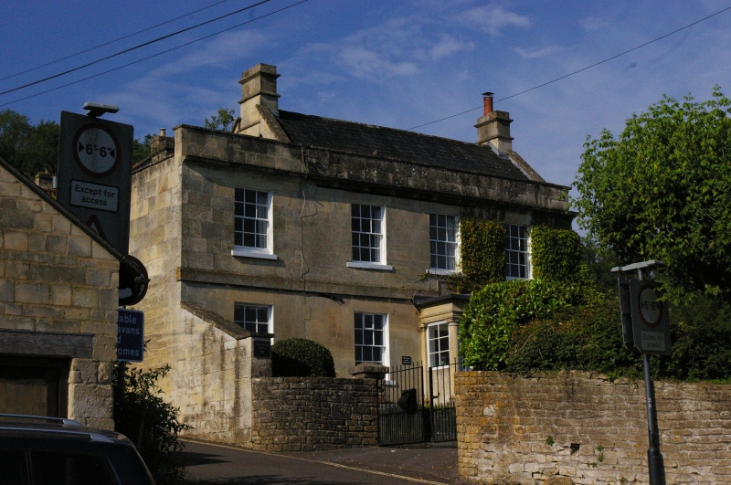
ST 7866-7966 BATHFORD C.P. HIGH STREET
(South-west side)
9/79
No. 142
G.V.
II
House. Mid - late C18th. Ashlar; slate roof with coped raised verges behind
parapet, cornice. 2 storeys. 3 bays, plus 1 in later extension to left.
Glazing bar sash windows. Plat band. Central 6 panel door; projecting porch
with Tuscan columns and entablature.
Listing NGR: ST7965166665
External links are from the relevant listing authority and, where applicable, Wikidata. Wikidata IDs may be related buildings as well as this specific building. If you want to add or update a link, you will need to do so by editing the Wikidata entry.


Other nearby listed buildings
