Latitude: 51.1442 / 51°8'39"N
Longitude: 0.8322 / 0°49'55"E
OS Eastings: 598201
OS Northings: 142142
OS Grid: TQ982421
Mapcode National: GBR RWV.76L
Mapcode Global: VHKKM.CHTP
Plus Code: 9F324RVJ+MV
Entry Name: 44 and 46, the Street
Listing Date: 10 October 1980
Grade: II
Source: Historic England
Source ID: 1116057
English Heritage Legacy ID: 180958
ID on this website: 101116057
Location: Great Chart, Ashford, Kent, TN23
County: Kent
District: Ashford
Civil Parish: Great Chart with Singleton
Built-Up Area: Ashford (Ashford)
Traditional County: Kent
Lieutenancy Area (Ceremonial County): Kent
Tagged with: Building
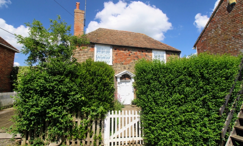
1.
5272 GREAT CHART THE STREET
(north-west side)
Nos 44 and 46
TQ 9842 26/17
II GV
2.
C18. Two storeys. Ground floor red brick, above tile-hung. Hipped tiled
roof. Two sashes with glazing bars intact. Doorcase with pilasters, pediment
and 6 panelled door. Set back behind a yard.
Listing NGR: TQ9820242143
External links are from the relevant listing authority and, where applicable, Wikidata. Wikidata IDs may be related buildings as well as this specific building. If you want to add or update a link, you will need to do so by editing the Wikidata entry.


Other nearby listed buildings