Approximate Location Map
Large Map »
Latitude: 52.4509 / 52°27'3"N
Longitude: -1.6727 / 1°40'21"W
OS Eastings: 422342
OS Northings: 283711
OS Grid: SP223837
Mapcode National: GBR 5K2.9Y7
Mapcode Global: VHBWN.YNLH
Plus Code: 9C4WF82G+9W
Entry Name: Footbridge over Weir, 150 Metres South East of Packington Hall
Listing Date: 23 March 1988
Grade: II
Source: Historic England
Source ID: 1116408
English Heritage Legacy ID: 308974
ID on this website: 101116408
Location: North Warwickshire, CV7
County: Warwickshire
District: North Warwickshire
Civil Parish: Great Packington
Traditional County: Warwickshire
Lieutenancy Area (Ceremonial County): Warwickshire
Church of England Parish: Meriden St Laurence
Church of England Diocese: Coventry
Tagged with: Footbridge
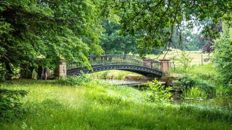
GREAT PACKINGTON PACKINGTON PARK
SP28SW
8/69 Footbridge over weir, 150m SE
of Packington Hall
GV II
Footbridge. Mid C19. Wrought-iron with rusticated sandstone piers at the ends.
Single span segmental arch. The wrought-iron parapet has ring shafted verticals
enriched with C scrolls and below a band of foliate paterae.
Listing NGR: SP2234283711
External links are from the relevant listing authority and, where applicable, Wikidata. Wikidata IDs may be related buildings as well as this specific building. If you want to add or update a link, you will need to do so by editing the Wikidata entry.


Other nearby listed buildings
