Approximate Location Map
Large Map »
Latitude: 52.0708 / 52°4'15"N
Longitude: -2.1111 / 2°6'39"W
OS Eastings: 392480
OS Northings: 241392
OS Grid: SO924413
Mapcode National: GBR 2K5.12Y
Mapcode Global: VH93G.C69T
Plus Code: 9C4V3VCQ+8H
Entry Name: Glebe
Listing Date: 3 August 1972
Grade: II
Source: Historic England
Source ID: 1116708
English Heritage Legacy ID: 442855
ID on this website: 101116708
Location: Eckington, Wychavon, Worcestershire, WR10
County: Worcestershire
District: Wychavon
Civil Parish: Eckington
Built-Up Area: Eckington
Traditional County: Worcestershire
Lieutenancy Area (Ceremonial County): Worcestershire
Church of England Parish: Eckington
Church of England Diocese: Worcester
Tagged with: Building
ECKINGTON ECKINGTON
1.
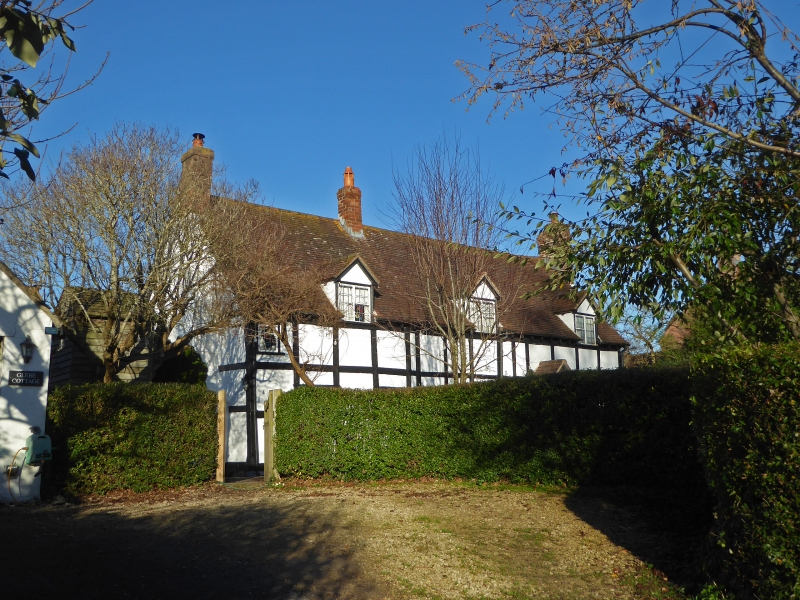
2301 School Lane
Nos 1 & 2 Glebe
SO 9241 23/354
II
2.
Cl7 timber frame cottage. Whitened brick nogging. Modern lead light casements.
3 gabled dormers. Modern doors. Tile roof with gabled ends.
Listing NGR: SO9248041392
External links are from the relevant listing authority and, where applicable, Wikidata. Wikidata IDs may be related buildings as well as this specific building. If you want to add or update a link, you will need to do so by editing the Wikidata entry.


Other nearby listed buildings
