Latitude: 53.4099 / 53°24'35"N
Longitude: -2.0799 / 2°4'47"W
OS Eastings: 394782
OS Northings: 390351
OS Grid: SJ947903
Mapcode National: GBR FYX0.HB
Mapcode Global: WHB9Y.0KT6
Plus Code: 9C5VCW5C+X2
Entry Name: Hydebank House
Listing Date: 25 April 1986
Grade: II
Source: Historic England
Source ID: 1117356
English Heritage Legacy ID: 442200
ID on this website: 101117356
Location: Romiley, Stockport, Greater Manchester, SK6
County: Stockport
Electoral Ward/Division: Bredbury Green and Romiley
Parish: Non Civil Parish
Traditional County: Cheshire
Lieutenancy Area (Ceremonial County): Greater Manchester
Church of England Parish: Romiley St Chad
Church of England Diocese: Chester
Tagged with: House
SJ99SW WERNETH OAKWOOD ROAD
1/215A (SOUTH SIDE)
HYDEBANK HOUSE
GV II
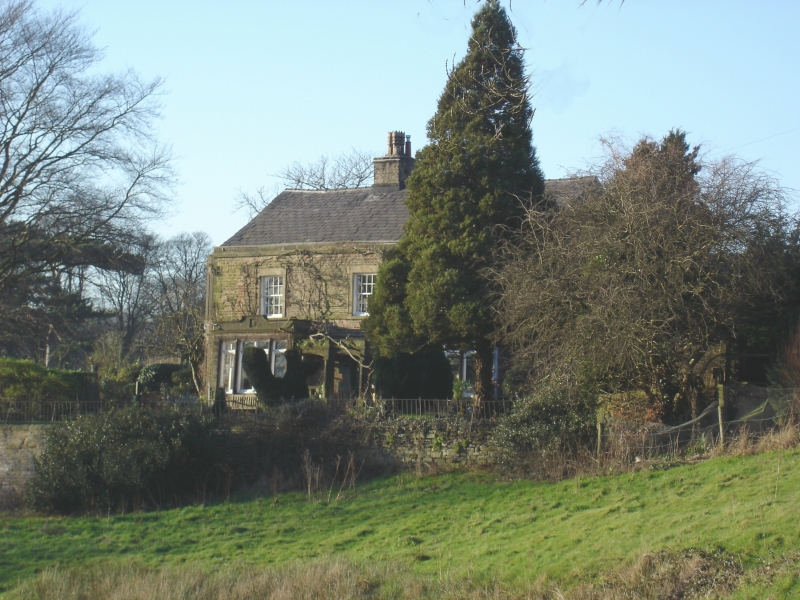
House - Possible C17 origin, but largely rebuilt in 1806 for Samuel Oldknow
and extensively remodelled in 1897. Coursed square rubble with some ashlar
(1897) and slate roofs. 3-bay central stair hall plan. It is a rebuilding of
the polite portion of an older house, which continued as the service wings. With
the remodelling in 1897, it became a separate property. 2 storeys and attic.
3-bay front. The ground floor has 1897 rectangular 3-light ashlar bays flanking
the 1806 entrance above 3 plate glass sashes in plain stone surrounds. Cornice.
2 ridge stacks curiously placed, the central one well clear of the fireplace
vertical. The side elevation west has a 2-storey canted bay of 1897 and the
east one a blocked 2-light mullioned window above a single light one, which are
very mysterious and may not be insitu. The attic floor of both gables is very
clearly a heightening of 1806 with the coursed square rubble of a quite different
character and this contains a Y-tracery window at each gable. The so-called
Oldknow windows, which the owner also introduced into his mills in the area.
Interior - The stair hall is stone flagged and has a stone staircase of 1806
with stick balusters and mahogony handrail with curtail. Detail is otherwise a
mixture of 1806 and 1897, apart from the c1870 introduced fireplace in the
drawing-room. There are a couple of Georgian hob grates, 2 1897 ceilings, a
cupboard, but nothing of real note. The principal interest of the House is the
historic association with the builder of 1806, Samuel Oldknow, a local mill owner
and the chief mover of the Peak Forest Canal which runs through Hydebank tunnel
under the garden before the House. This association, together with its group
value with the older Hydebank Farmhouse, makes the House, with some architectural
interest, listable.
Listing NGR: SJ9478290351
External links are from the relevant listing authority and, where applicable, Wikidata. Wikidata IDs may be related buildings as well as this specific building. If you want to add or update a link, you will need to do so by editing the Wikidata entry.


Other nearby listed buildings