Latitude: 51.7761 / 51°46'33"N
Longitude: -0.8762 / 0°52'34"W
OS Eastings: 477632
OS Northings: 209201
OS Grid: SP776092
Mapcode National: GBR C1X.M8W
Mapcode Global: VHDV9.RMN9
Plus Code: 9C3XQ4GF+CG
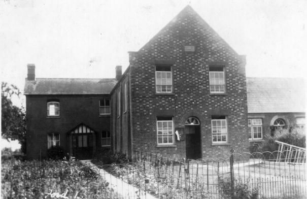
Entry Name: General Baptist Chapel
Listing Date: 12 August 1983
Grade: II
Source: Historic England
Source ID: 1118299
English Heritage Legacy ID: 43057
ID on this website: 101118299
Location: Ford, Buckinghamshire, HP17
County: Buckinghamshire
Civil Parish: Dinton-with-Ford and Upton
Traditional County: Buckinghamshire
Lieutenancy Area (Ceremonial County): Buckinghamshire
Church of England Parish: Stone with Dinton and Hartwell
Church of England Diocese: Oxford
Tagged with: Chapel
SP 70 NE DINTON-WITH-FORD AND CHAPEL ROAD, Ford UPTON (south side)
7/120 General Baptist Chapel
12.8.83
GV II
Baptist Chapel built 1716; heightened and enlarged in 1829; new entrance bay added in 1852. Refitted internally in 1884. 4 bays. Two storeyfront. North-east side and rear walls of witchert and rendered stone rubble relating to 1716 structure with C19 brick pilaster strips dividing the bays. North-west entrace front of red brick with vitreous headers. Tiled roof, half-hipped to rear with coped gable to entrance front with date stone in centre inscribed "Built 1716 Enlarged 1852". North east side wall with two round arched windows with Y-tracery. Two window entrance front with gauged flat brick arches to recessed sash windows with glazing bars. Central round arched doorway with radial fanlight and panelled door;one storey Sunday School of 1884 on south west side.
Listing NGR: SP7763209201
External links are from the relevant listing authority and, where applicable, Wikidata. Wikidata IDs may be related buildings as well as this specific building. If you want to add or update a link, you will need to do so by editing the Wikidata entry.


Other nearby listed buildings