Latitude: 51.7881 / 51°47'17"N
Longitude: -0.8964 / 0°53'47"W
OS Eastings: 476216
OS Northings: 210514
OS Grid: SP762105
Mapcode National: GBR C1P.VK6
Mapcode Global: VHDV9.DBY2
Plus Code: 9C3XQ4Q3+6C
Entry Name: Wootton's Farmhouse
Listing Date: 11 October 1985
Grade: II
Source: Historic England
Source ID: 1118306
English Heritage Legacy ID: 43077
ID on this website: 101118306
Location: Dinton, Buckinghamshire, HP17
County: Buckinghamshire
Civil Parish: Dinton-with-Ford and Upton
Built-Up Area: Dinton
Traditional County: Buckinghamshire
Lieutenancy Area (Ceremonial County): Buckinghamshire
Church of England Parish: Stone with Dinton and Hartwell
Church of England Diocese: Oxford
Tagged with: Farmhouse Thatched farmhouse
SP 71 SE DINTON-WITH-FORD AND HIGH STREET, Westlington UPTON (north side)
3/140 Wootton's Farmhouse
-
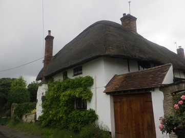
GV II
House. C17, enlarged C18. C17 timber-framed with plastered infill. C18 parts witchert, rendered on a rubblestone plinth, all colourwashed. Half-hipped thatched roofs. Letter-L plan with C18 range fronting road and C17 range at right angles at north. 2 bay street front, 3½ bay north west range. 2 storeys, attic to C18 range. C17 bays timber- framed upper floor, part witchert ground floor. Entrance in angle between wings in porch. Windows formerly leaded casements with iron opening casements, but leads mostly replaced by plain glass. 2 and 3-lights. C17 stack of old thin bricks in north west range. Colourwashed rubblestone projecting and weathered stack off centre to street front with brick flue. Brick half gable to C18 range, which has thatched outshot to its rear in angle. Interior has inglenook fireplaces and chamfered and stopped spine beams. The timber-framed C17 rangeof 3 bays stops short of the roadside, but C18 wing added a half bay to reach the road and extended to left to form letter-L plan. RCHM I. 127. MON.18.
Listing NGR: SP7621610514
External links are from the relevant listing authority and, where applicable, Wikidata. Wikidata IDs may be related buildings as well as this specific building. If you want to add or update a link, you will need to do so by editing the Wikidata entry.


Other nearby listed buildings