Latitude: 50.7925 / 50°47'33"N
Longitude: -1.9779 / 1°58'40"W
OS Eastings: 401653
OS Northings: 99220
OS Grid: SZ016992
Mapcode National: GBR 31T.BR7
Mapcode Global: FRA 66RZ.THC
Plus Code: 9C2WQ2VC+2R
Entry Name: Canford Bridge
Listing Date: 14 June 1952
Grade: II
Source: Historic England
Source ID: 1119555
English Heritage Legacy ID: 107118
Also known as: Canford Bridge and viaduct approach to south
ID on this website: 101119555
Location: St Johns, Dorset, BH21
County: Dorset
Civil Parish: Wimborne Minster
Built-Up Area: Wimborne Minster
Traditional County: Dorset
Lieutenancy Area (Ceremonial County): Dorset
Church of England Parish: Wimborne St John the Evangelist
Church of England Diocese: Salisbury
Tagged with: Bridge Road bridge
The asset was previously listed twice also under the district of Poole at List Entry 1217511. That entry was removed from the List on 26 July 2023.
This entry was subject to a Minor Amendment on 26 July 2023 to add details from the delisted duplicate entry and to reformat text to current standards.
This list entry was subject to a Minor Amendment on 13 December 2021 to update text and reformat to current standards.
SZ 0199
1/94
POOLE ROAD and OAKLEY HILL, B3078
Canford Bridge
14.6.52
II
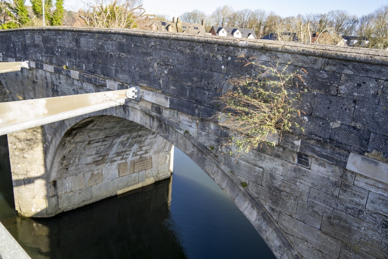
Built 1813 by John Dyson, Engineer with C19 and C20 repairs. Road bridge of three arches over the River Stour with approach to the south. Coursed squared Portland stone and Portland stone ashlar to bridge, coursed squared carstone, carstone ashlar and red brick to approach. Three high segmental arches, pointed cutwaters either side and solid coped parapet with moulded stone coping square pier terminals. Stone in north pier of central arch facing south, not far above water level, inscribed: THIS BRIDGE FINISHED / IN THE YEAR 1813 / BY, / JOHN DYSON, ENGINEER / JESSE BUSHROD, MASON. South approach to bridge has six segmental arches, semicircular cutwaters and solid parapets of red brick in English bond with stone coping. Raised stone band at road level. Arches of red brick. Bridges carries the B3078 road.
External links are from the relevant listing authority and, where applicable, Wikidata. Wikidata IDs may be related buildings as well as this specific building. If you want to add or update a link, you will need to do so by editing the Wikidata entry.


Other nearby listed buildings