Approximate Location Map
Large Map »
Latitude: 50.803 / 50°48'10"N
Longitude: -2.071 / 2°4'15"W
OS Eastings: 395091
OS Northings: 100381
OS Grid: ST950003
Mapcode National: GBR 31H.K7N
Mapcode Global: FRA 66KZ.10Y
Plus Code: 9C2VRW3H+5H
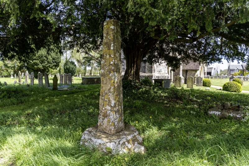
Entry Name: Churchyard Cross 15 Metres South West of Tower
Listing Date: 18 March 1955
Grade: II
Source: Historic England
Source ID: 1120059
English Heritage Legacy ID: 107688
ID on this website: 101120059
Location: St Mary's Church, Sturminster Marshall, Dorset, BH21
County: Dorset
Civil Parish: Sturminster Marshall
Built-Up Area: Sturminster Marshall
Traditional County: Dorset
Lieutenancy Area (Ceremonial County): Dorset
Church of England Parish: Sturminster Marshall St Mary
Church of England Diocese: Salisbury
STURMINSTER MARSHALL
ST 90 SE
CHURCH STREET
4/63
Churchyard Cross 15
18.3.55 Metres South West of
Tower
- II
Cross. C14. Stone. Tapered shaft with moulded angles, set on a chamfered
octagonal base, with shaped spures. Ancient Monument (County Ref No. 653).
RCHM
Listing NGR: ST9509100381
External links are from the relevant listing authority and, where applicable, Wikidata. Wikidata IDs may be related buildings as well as this specific building. If you want to add or update a link, you will need to do so by editing the Wikidata entry.


Other nearby listed buildings
