Latitude: 54.5662 / 54°33'58"N
Longitude: -1.6896 / 1°41'22"W
OS Eastings: 420166
OS Northings: 519039
OS Grid: NZ201190
Mapcode National: GBR JHNM.0X
Mapcode Global: WHC5N.0HPB
Plus Code: 9C6WH886+F5
Entry Name: The Grange and Attached Farmbuilding to South
Listing Date: 16 July 1986
Grade: II
Source: Historic England
Source ID: 1121164
English Heritage Legacy ID: 110898
ID on this website: 101121164
Location: Summerhouse, Darlington, County Durham, DL2
County: Darlington
Civil Parish: Summerhouse
Traditional County: Durham
Lieutenancy Area (Ceremonial County): County Durham
Church of England Parish: Ingleton
Church of England Diocese: Durham
Tagged with: Building
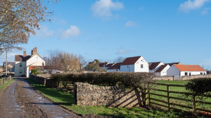
NZ 2019 SUMMERHOUSE SUMMERHOUSE
(South side)
14/90 The Grange and
attached farmbuilding
to south
GV II
Large farmhouse and farmbuilding. C17, perhaps incorporating earlier masonry,
with major alterations. Early C19 farmbuilding. Rubble painted white. House
replaced pantiles and brick chimney stacks; farmbuilding old pantiles.
Reversed U-plan farmhouse with added bay and farmbuilding to left.
2-storey, irregular 5-bay farmhouse. 6-panel door in fourth bay. Altered
openings: C20 casements, glazed porch and replaced sash on ground floor;
replaced 4-pane sashes above with wedge lintels and projecting sills. Fire
insurance mark on first floor between right end bays. Steeply-pitched roof
with coped gables and shaped kneelers. Massive off-centre ridge stack with
rebuilt brick top; rebuilt brick end stacks. Stepped external chimney on
right return.
Lower 2-storey added left bay has replaced door and end stack.
Single-storey farmbuilding with loft has 2 boarded doors at right and external
stone stairway on left return.
Single-storey outshut flanked by 2-storey gabled wings on rear of house.
Modernised interior: 1.75-metre thick full-height cross wall below ridge
stack; ground-floor rooms retain some chamfered ceiling beams.
Listing NGR: NZ2016619039
External links are from the relevant listing authority and, where applicable, Wikidata. Wikidata IDs may be related buildings as well as this specific building. If you want to add or update a link, you will need to do so by editing the Wikidata entry.


Other nearby listed buildings