Latitude: 54.7755 / 54°46'31"N
Longitude: -1.5745 / 1°34'28"W
OS Eastings: 427470
OS Northings: 542369
OS Grid: NZ274423
Mapcode National: GBR KFF6.XX
Mapcode Global: WHC4Q.S7FC
Plus Code: 9C6WQCGG+56
Entry Name: Salvation Army Citadel
Listing Date: 19 October 1962
Last Amended: 10 March 1988
Grade: II*
Source: Historic England
Source ID: 1121360
English Heritage Legacy ID: 110452
ID on this website: 101121360
Location: The Sands, County Durham, DH1
County: County Durham
Electoral Ward/Division: Elvet and Gilesgate
Parish: City of Durham
Built-Up Area: Durham
Traditional County: Durham
Lieutenancy Area (Ceremonial County): County Durham
Tagged with: Architectural structure
DURHAM AND FRAMWELLGATE SADDLER STREET
NZ 2742 SW (East side)
14/397 Nos. 47 and 48
(Salvation Army Citadel)
19.10.62 (formerly listed as
Nos. 48 and 49)
GV II*
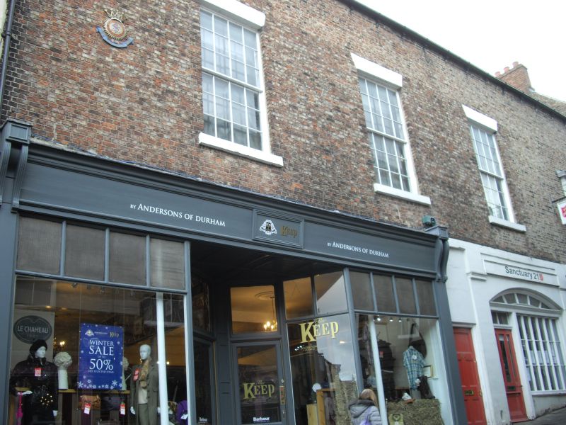
Assembly rooms and shops, incorporating part of North Gate of Castle; now
Salvation Army meeting hall and university department. Medieval gate. Circa
1800 assembly rooms with ground floor alterations. Ground floor rendered;
first floor English bond brick with painted ashlar dressings; Welsh slate roof
with brick chimneys. Circa 1900 shop at left has recessed central door; upper
glazing bars in shop windows. Central c.1800 shop has partly-glazed door and
2-pane overlight at left, and shop window with 3 rows of 6 panes at right, under
patterned shallow segmental lunette. Assembly rooms entrance at right has
many-panelled door in Greek Doric doorcase with columns and entablature, flanking
narrow sashes with projecting stone sills. First floor has 3 large sash windows
above shops, with wedge stone lintels, projecting stone sills, and glazing bars;
wide blank right bay has painted SALVATION ARMY in aedicule. Low-pitched roof
has end brick chimney.
Interior: wide open-string stair has swept wreath and curtail, round handrail
on stick balusters. Reported to contain fragments of North Gate barbican in
basement. Graded for medieval parts.
Listing NGR: NZ2747642386
External links are from the relevant listing authority and, where applicable, Wikidata. Wikidata IDs may be related buildings as well as this specific building. If you want to add or update a link, you will need to do so by editing the Wikidata entry.


Other nearby listed buildings