Latitude: 54.5804 / 54°34'49"N
Longitude: -1.801 / 1°48'3"W
OS Eastings: 412962
OS Northings: 520600
OS Grid: NZ129206
Mapcode National: GBR HHVG.WT
Mapcode Global: WHC5L.94ND
Plus Code: 9C6WH5JX+5J
Entry Name: Wall, Gateway, Carriage-House and Stable Attached
Listing Date: 30 September 1987
Grade: II
Source: Historic England
Source ID: 1121756
English Heritage Legacy ID: 111504
ID on this website: 101121756
Location: Staindrop, County Durham, DL2
County: County Durham
Civil Parish: Staindrop
Built-Up Area: Staindrop
Traditional County: Durham
Lieutenancy Area (Ceremonial County): County Durham
Church of England Parish: Staindrop
Church of England Diocese: Durham
Tagged with: Wall
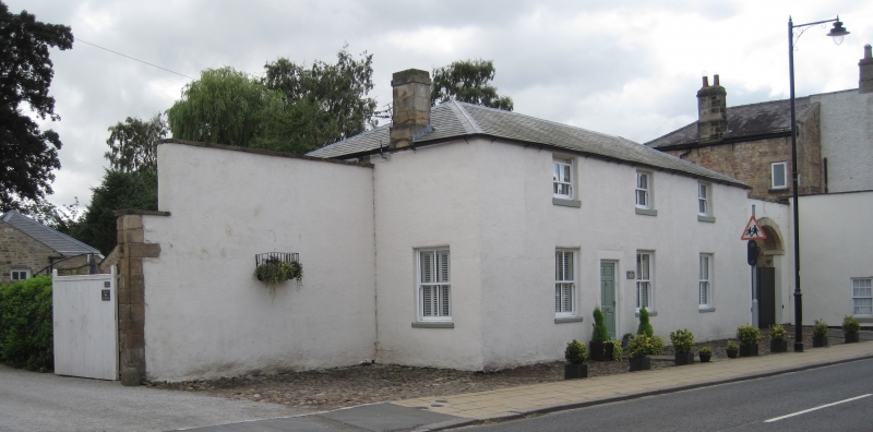
STAINDROP FRONT STREET NZ 1320 (South side) 18/139 Wall, gateway, carriage-house and stable attached to Staindrop Hall
GV II
Yard wall with gateway, carriage house and stables. Third quarter C18. Sandstone rubble withquoins and ashlar dressings; rear elevation rendered sandstone rubble with quoins and brick and ashlar dressings; roof of graduated Lakeland slate with ashlar chimney. 2 storeys, 3 bays and high wall attached at left.
Wall has boarded pedestrian to left of high segmental-headed vehicle arch with voussoirs; renewed boarded double doors; flat stone coping. Carriage- house and stable has 3 high hit-and-miss loft openings with projecting stone sills; hipped roof with left end chimney at eaves. South elevation to yard shows boarded door and 2-pane overlight at left, and partly-glazed opening between that and 2 segmental-headed coach entrances with boarded doors; 3 loft openings, the 2 left boarded, the right a horizontal sliding sash with glazing bars, have projecting stone sills. Right return has side stone steps, the ends shaped to form continuous stepped curve, to first floor boarded door.
Interior: quadrant hay store at left of first door; circular hay racks to 4 stalls, 2 with mangers.
This stable block is in the style of some of those built at Raby Castle by J. Paine. It balances the one-storey wing to Staindrop Hall which is adjacent to the gateway.
Listing NGR: NZ1302220600
External links are from the relevant listing authority and, where applicable, Wikidata. Wikidata IDs may be related buildings as well as this specific building. If you want to add or update a link, you will need to do so by editing the Wikidata entry.


Other nearby listed buildings