Approximate Location Map
Large Map »
Latitude: 51.1386 / 51°8'19"N
Longitude: 0.4293 / 0°25'45"E
OS Eastings: 570045
OS Northings: 140511
OS Grid: TQ700405
Mapcode National: GBR NRB.FCV
Mapcode Global: VHJMY.DN90
Plus Code: 9F324CQH+CP
Entry Name: The Gun and Spitroast Public House and Rear Courtyard
Listing Date: 10 October 1989
Grade: II
Source: Historic England
Source ID: 1121941
English Heritage Legacy ID: 169954
ID on this website: 101121941
Location: Horsmonden, Tunbridge Wells, Kent, TN12
County: Kent
District: Tunbridge Wells
Civil Parish: Horsmonden
Built-Up Area: Horsmonden
Traditional County: Kent
Lieutenancy Area (Ceremonial County): Kent
Church of England Parish: Horsmonden St Margaret
Church of England Diocese: Rochester
Tagged with: Pub
HORSMONDEN THE HEATH
TQ 7040-7140
(south side)
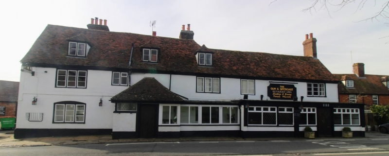
7/118 The Gun and Spitroast
Public House and rear
courtyard.
GV II
Public House. C17 or earlier, altered and extended C18 and early C19.
Timber framed and tile hung, extended with painted brick. Plain tiled roofs.
Two parallel ranges extended to right. Two storeys and attic on plinth with discontinuous plat band and moulded wooden eaves cornice to roof hipped to
right, gabled to left with stacks to rear left and to rear right and 3
hipped dormers. Ridge line stepped down to right to 2 storeys with stack at
end right. Five 2 and 3 light wooden casements on first floor and 3 light casement to left on ground floor with segmental head, with large hipped
porch to centre left with 4 centred arched boarded door; right hand section
with ground floor built out with plate glass picture windows and boarded door
to right. Rear wing of 2 storeys, gabled with projecting cross-wing at left
with hipped roof and gablet. Small rear courtyard with early C19 single
storey outbuildings of red brick and plain tiled roofs.
Interior: altered late C2O, but with elements of the original frame still visible, and with inglenook fireplace. The original name was The Gun, first licensed in the 1570's and licensed as a forge in 1618. The Heath, now the village centre, is some 2 miles from the church, and grew up as a result of
the C16/C17 iron industry, especially that belonging to the Brown family,
Royal Gunfounders, their mill pond at Shirrenden surviving half a mile to
the north-east.
Listing NGR: TQ7004540511
External links are from the relevant listing authority and, where applicable, Wikidata. Wikidata IDs may be related buildings as well as this specific building. If you want to add or update a link, you will need to do so by editing the Wikidata entry.


Other nearby listed buildings
