Latitude: 51.1157 / 51°6'56"N
Longitude: 0.4277 / 0°25'39"E
OS Eastings: 570016
OS Northings: 137960
OS Grid: TQ700379
Mapcode National: GBR NRJ.T51
Mapcode Global: VHJN4.C7G1
Plus Code: 9F324C8H+73
Entry Name: Walls and Stable Range Attached to South and East of Elphicks
Listing Date: 10 October 1989
Grade: II
Source: Historic England
Source ID: 1121963
English Heritage Legacy ID: 169947
ID on this website: 101121963
Location: Tunbridge Wells, Kent, TN12
County: Kent
District: Tunbridge Wells
Civil Parish: Horsmonden
Traditional County: Kent
Lieutenancy Area (Ceremonial County): Kent
Church of England Parish: Horsmonden St Margaret
Church of England Diocese: Rochester
Tagged with: Wall
HORSMONDEN SPELMONDEN ROAD TQ 63 NE & TQ 73 NW (east side) 3 & 4/111 Walls and stable range attached to south and east of Elphicks GV II
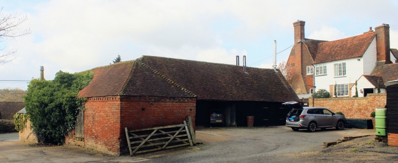
Walls and stable ranges. C18 or earlier, altered and extended early C19. The wall enclosing the front garden of Elphicks is of red brick, some 3 feet high with coping to the front of the house, returned to right , ramped up to about 5 feet and buttressed with a gateway and fencing to the adjacent stable ranges/sheds. Main block timber framed on stone and red brick base and weather boarded with plain tiled roof. Single storey hipped building, the eastern face open sided for cart entries. Red brick crosswing at end right, the lower courses in English bond, with plain tiled roof. Single storey on plinth (with some sandstone to left) with brick dentil eaves cornice to hipped roof with stacks to centre forward and projecting at end left of principal, i.e. right return elevation. Boarded door to right and blocked-in doorway to left, the latter with mounting block/steps. Two central window openings. Single storey C19 extension of red brick with slate roof and carriage doors projecting to the roadside from this crosswing.
Listing NGR: TQ6998037934
External links are from the relevant listing authority and, where applicable, Wikidata. Wikidata IDs may be related buildings as well as this specific building. If you want to add or update a link, you will need to do so by editing the Wikidata entry.


Other nearby listed buildings