Approximate Location Map
Large Map »
Latitude: 51.9056 / 51°54'20"N
Longitude: 0.5686 / 0°34'7"E
OS Eastings: 576796
OS Northings: 226129
OS Grid: TL767261
Mapcode National: GBR PHK.DL3
Mapcode Global: VHJJB.SCZH
Plus Code: 9F32WH49+7F
Entry Name: Harriets Farmhouse
Listing Date: 29 November 1973
Grade: II
Source: Historic England
Source ID: 1122488
English Heritage Legacy ID: 113721
ID on this website: 101122488
Location: High Garrett, Braintree, Essex, CM7
County: Essex
District: Braintree
Electoral Ward/Division: Bocking North
Parish: Non Civil Parish
Built-Up Area: Braintree
Traditional County: Essex
Lieutenancy Area (Ceremonial County): Essex
Church of England Parish: Bocking
Church of England Diocese: Chelmsford
Tagged with: Farmhouse
885
TL 7626
10/191
CHURCH STREET
(North West Side)
BOCKING CHURCH STREET
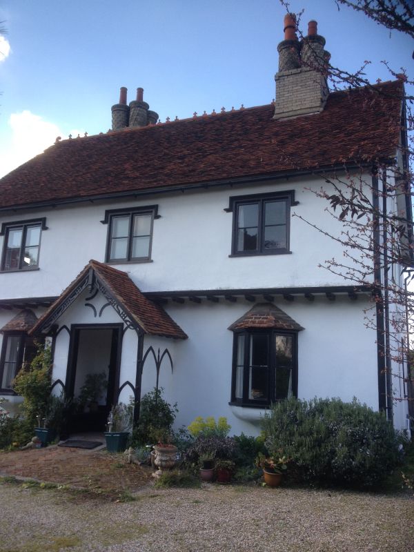
No 257 (Harriets Farmhouse)
II
An early/mid C19 farmhouse built in the Tudor style. 2 storeys. The upper
storey is jet tied on the front. 3 window range, 2-light casements with stucco hood moulds. The ground storey has 2 oriel bays and a central gabled porch.
The porch and gables on the north and south ends have pierced and shaped bargeboards. Roof tiled, with 2 chimney stacks with 4 moulded brick circular shafts with lattice and spiral ornamentation.
Listing NGR: TL7679626129
External links are from the relevant listing authority and, where applicable, Wikidata. Wikidata IDs may be related buildings as well as this specific building. If you want to add or update a link, you will need to do so by editing the Wikidata entry.


Other nearby listed buildings
