Approximate Location Map
Large Map »
Latitude: 51.4843 / 51°29'3"N
Longitude: -0.1227 / 0°7'21"W
OS Eastings: 530446
OS Northings: 177822
OS Grid: TQ304778
Mapcode National: GBR JQ.L2
Mapcode Global: VHGQZ.TYHH
Plus Code: 9C3XFVMG+PW
Entry Name: 29, South Lambeth Road SW8
Listing Date: 18 June 1974
Grade: II
Source: Historic England
Source ID: 1124174
English Heritage Legacy ID: 204625
Also known as: 29 South Lambeth Road
27-29, South Lambeth Road SW8
ID on this website: 101124174
Location: Lambeth, London, SW8
County: London
District: Lambeth
Electoral Ward/Division: Oval
Parish: Non Civil Parish
Built-Up Area: Lambeth
Traditional County: Surrey
Lieutenancy Area (Ceremonial County): Greater London
Church of England Parish: South Lambeth St Anne and All Saints
Church of England Diocese: Southwark
Tagged with: Building
1.
5023
TQ 3077
7/845
18.6.74
SOUTH LAMBETH ROAD SW8
(east side)
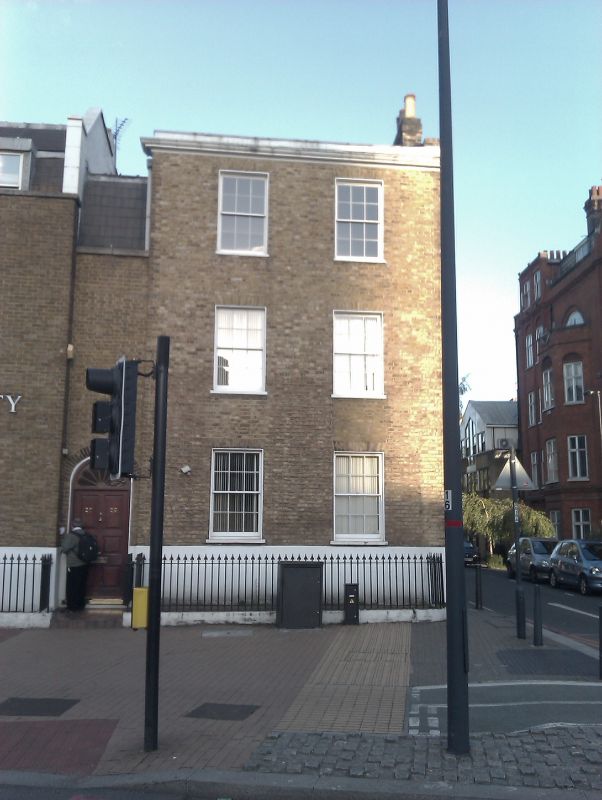
No 29
II
2.
Early C19 house of three storeys and basement, two windows, with one storey left
entrance bay. Stock brick with stone cornice and blocking course, stuccoed basement.
Gauged near-flat brick arches to replaced sash windows in stucco-lined reveals.
Flushed door, with cornice head and plain fanlight, under round gauged brick arch.
Listing NGR: TQ3044677822
External links are from the relevant listing authority and, where applicable, Wikidata. Wikidata IDs may be related buildings as well as this specific building. If you want to add or update a link, you will need to do so by editing the Wikidata entry.


Other nearby listed buildings
