Latitude: 54.3891 / 54°23'20"N
Longitude: -2.8761 / 2°52'33"W
OS Eastings: 343206
OS Northings: 499642
OS Grid: SD432996
Mapcode National: GBR 8KCP.4D
Mapcode Global: WH82F.SYM4
Plus Code: 9C6V94QF+JH
Entry Name: Mislet Farmhouse
Listing Date: 7 February 1973
Grade: II
Source: Historic England
Source ID: 1124690
English Heritage Legacy ID: 351677
ID on this website: 101124690
Location: Westmorland and Furness, Cumbria, LA23
County: Cumbria
District: South Lakeland
Civil Parish: Windermere
Traditional County: Westmorland
Lieutenancy Area (Ceremonial County): Cumbria
Church of England Parish: Windermere (Applethwaite) St Mary
Church of England Diocese: Carlisle
Tagged with: Farmhouse
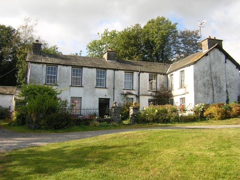
HEANING LANE
1.
1834
Mislet Farmhouse
SD 49 NW 4/74
II
2.
C17, altered later. Roughcast stone rubble, old slate roof, L plan, 2
low storeys. Door with fanlight, 4 windows on ground floor and 5 above
(mostly 12-paned sashes) all on long arm of L. Short arm has 2 sash windows
on each floor.
Listing NGR: SD4320699642
External links are from the relevant listing authority and, where applicable, Wikidata. Wikidata IDs may be related buildings as well as this specific building. If you want to add or update a link, you will need to do so by editing the Wikidata entry.


Other nearby listed buildings