Latitude: 51.6406 / 51°38'26"N
Longitude: -0.8159 / 0°48'57"W
OS Eastings: 482034
OS Northings: 194192
OS Grid: SU820941
Mapcode National: GBR D51.4JZ
Mapcode Global: VHDW3.T105
Plus Code: 9C3XJ5RM+6J
Entry Name: Myze Farmhouse
Listing Date: 28 June 1973
Grade: II
Source: Historic England
Source ID: 1125087
English Heritage Legacy ID: 46173
ID on this website: 101125087
Location: West Wycombe, Buckinghamshire, HP14
County: Buckinghamshire
Civil Parish: West Wycombe
Traditional County: Buckinghamshire
Lieutenancy Area (Ceremonial County): Buckinghamshire
Church of England Parish: West Wycombe
Church of England Diocese: Oxford
Tagged with: Farmhouse
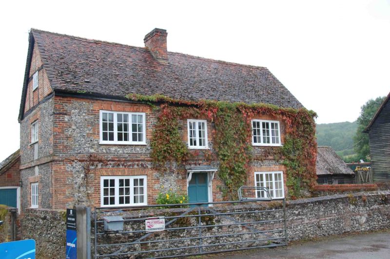
WEST WYCOMBE
1.
963
Myze Farmhouse
SU 89 SW 13/337
II
2.
Late C17. Two storeys, flint, brick dressings. Three casements outer
ones three light, centre two light. Central door flat hood on brackets.
old,tile roof, central stack. Gable ends (with half timbering in top).
Listing NGR: SU8203494192
External links are from the relevant listing authority and, where applicable, Wikidata. Wikidata IDs may be related buildings as well as this specific building. If you want to add or update a link, you will need to do so by editing the Wikidata entry.


Other nearby listed buildings