Approximate Location Map
Large Map »
Latitude: 51.6363 / 51°38'10"N
Longitude: -0.8049 / 0°48'17"W
OS Eastings: 482805
OS Northings: 193733
OS Grid: SU828937
Mapcode National: GBR D52.7BT
Mapcode Global: VHDW4.04BF
Plus Code: 9C3XJ5PW+G2
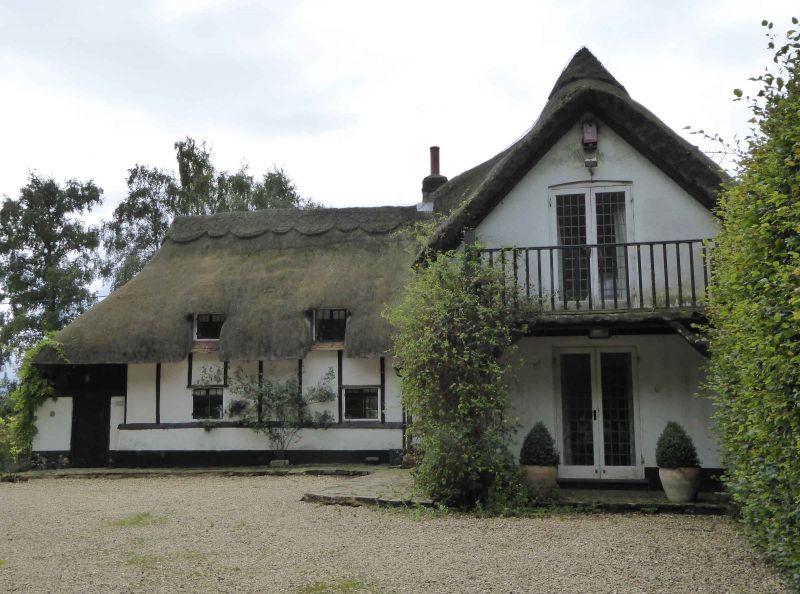
Entry Name: Thatch
Listing Date: 28 June 1973
Grade: II
Source: Historic England
Source ID: 1125116
English Heritage Legacy ID: 46137
ID on this website: 101125116
Location: West Wycombe, Buckinghamshire, HP14
County: Buckinghamshire
Civil Parish: West Wycombe
Traditional County: Buckinghamshire
Lieutenancy Area (Ceremonial County): Buckinghamshire
Church of England Parish: West Wycombe
Church of England Diocese: Oxford
Tagged with: Building Thatched cottage
TOWERIDGE
1.
963
WEST WYCOMBE
"Thatch"
SU 8293 10/19
II
2.
Formerly shown as Cottage on South side of Toweridge Common 200 yards north
west of Druid's Hut. C18 or earlier, timber framed with colour washed
brick nogging. Thatched roof swept down at either end over doorways.
2 lattice casement windows. Previously known as The Hermitage.
Listing NGR: SU8280593733
External links are from the relevant listing authority and, where applicable, Wikidata. Wikidata IDs may be related buildings as well as this specific building. If you want to add or update a link, you will need to do so by editing the Wikidata entry.


Other nearby listed buildings
