Approximate Location Map
Large Map »
Latitude: 51.6304 / 51°37'49"N
Longitude: -0.751 / 0°45'3"W
OS Eastings: 486546
OS Northings: 193134
OS Grid: SU865931
Mapcode National: GBR D54.NYC
Mapcode Global: VHDW4.X9V0
Plus Code: 9C3XJ6JX+4J
Entry Name: 3, Castle Street
Listing Date: 28 June 1973
Grade: II
Source: Historic England
Source ID: 1125213
English Heritage Legacy ID: 45972
ID on this website: 101125213
Location: High Wycombe, Buckinghamshire, HP13
County: Buckinghamshire
Electoral Ward/Division: Abbey
Parish: Non Civil Parish
Built-Up Area: High Wycombe
Traditional County: Buckinghamshire
Lieutenancy Area (Ceremonial County): Buckinghamshire
Church of England Parish: High Wycombe All Saints
Church of England Diocese: Oxford
Tagged with: Building
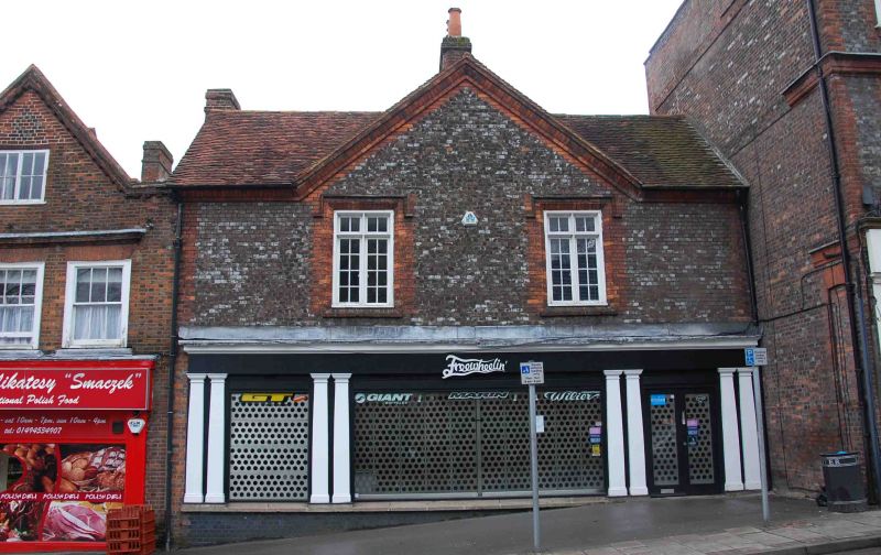
CASTLE STREET
1.
963
SU 8693 SE 2/29 No 3
II GV
2.
Formerly shown as Premises adjoining and immediately east of The Priory,
Circa 1840 front to an older building. Plum coloured bricks with red brick
dressings, old tiled roof. 2 storeys, symmetrical composition with central
gable embracing 2 bays of 4 light mullioned and transomed casement windows
with chamfered surrounds and dripmoulds. 3 centred arched glazed doors
in corners.
Priory House Annexe and Nos 1 to 7 (odd) form a group.
Listing NGR: SU8654793139
External links are from the relevant listing authority and, where applicable, Wikidata. Wikidata IDs may be related buildings as well as this specific building. If you want to add or update a link, you will need to do so by editing the Wikidata entry.


Other nearby listed buildings
