Approximate Location Map
Large Map »
Latitude: 51.7578 / 51°45'28"N
Longitude: -0.7811 / 0°46'52"W
OS Eastings: 484224
OS Northings: 207272
OS Grid: SP842072
Mapcode National: GBR D3K.MBT
Mapcode Global: VHDVK.D2XS
Plus Code: 9C3XQ659+4G
Entry Name: Dunrobin House
Listing Date: 26 April 1985
Grade: II
Source: Historic England
Source ID: 1125878
English Heritage Legacy ID: 46274
ID on this website: 101125878
Location: Butler's Cross, Buckinghamshire, HP17
County: Buckinghamshire
Civil Parish: Ellesborough
Built-Up Area: Ellesborough
Traditional County: Buckinghamshire
Lieutenancy Area (Ceremonial County): Buckinghamshire
Church of England Parish: Ellesborough
Church of England Diocese: Oxford
Tagged with: House
SP 80 NW ELLESBOROUGH CHALKSHIRE ROAD
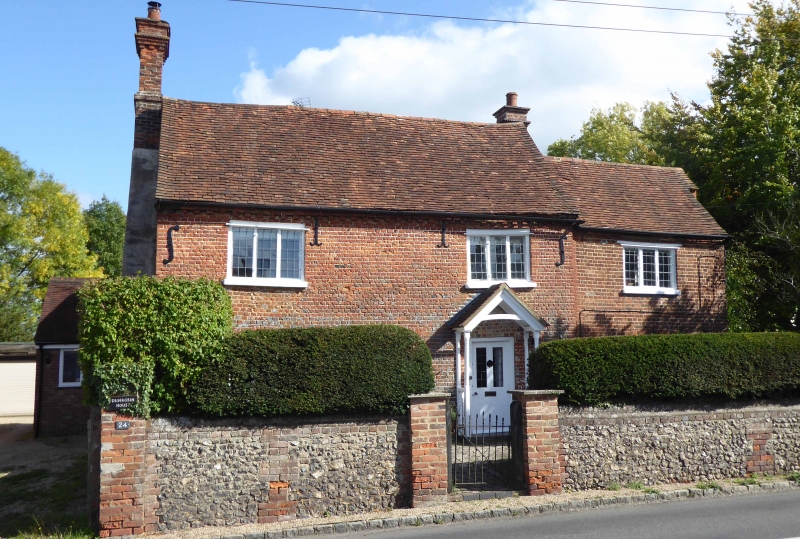
2/5 Dunrobin House
-
- II
House. Circa 1800 with early-mid C19 extensions to right and rear.
2 original bays are of red and vitreous header brick with red brick
quoins and dentil eaves. Old tile roof. External brick chimney to
left with dentil head, part rendered; smaller chimney to right.
2 storeys. 3-light leaded casements to first floor and to ground floor
left, the latter with segmental head. 2-light casement to centre of
ground floor, probably in blocked doorway. Half-glazed door to right
in altered opening with C20 gabled porch. Early C19 bay to right, of
red brick with off-set eaves and 2 storeys of 3-light leaded casements.
Flint and brick extensions to rear, of 2 builds, with hipped tile
roofs.
Listing NGR: SP8422407272
External links are from the relevant listing authority and, where applicable, Wikidata. Wikidata IDs may be related buildings as well as this specific building. If you want to add or update a link, you will need to do so by editing the Wikidata entry.


Other nearby listed buildings
