Approximate Location Map
Large Map »
Latitude: 52.556 / 52°33'21"N
Longitude: 0.1849 / 0°11'5"E
OS Eastings: 548220
OS Northings: 297592
OS Grid: TL482975
Mapcode National: GBR M4F.RKB
Mapcode Global: VHHHL.503X
Plus Code: 9F42H54M+9X
Entry Name: Christchurch Farm
Listing Date: 31 October 1983
Last Amended: 30 April 1985
Grade: II
Source: Historic England
Source ID: 1125932
English Heritage Legacy ID: 48161
ID on this website: 101125932
Location: Fenland, Cambridgeshire, PE14
County: Cambridgeshire
District: Fenland
Civil Parish: Christchurch
Traditional County: Cambridgeshire
Lieutenancy Area (Ceremonial County): Cambridgeshire
Church of England Parish: Christchurch
Church of England Diocese: Ely
Tagged with: Building
This list entry was subject to a Minor Amendment on 9 September 2021 to remove superfluous amendment details and to reformat the text to current standards
TF 49 NE
18/112
UPWELL
SIXTEEN FOOT BANK (West Side)
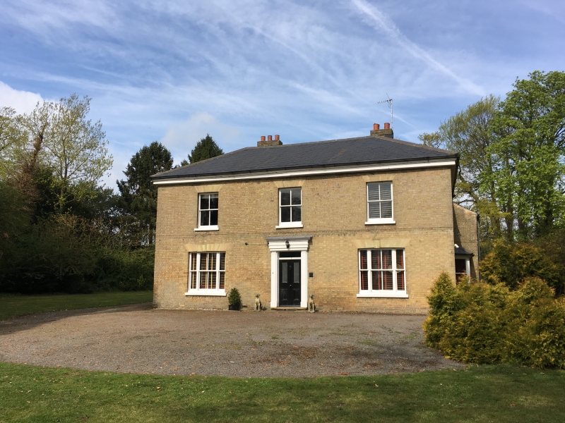
Christchurch Farm
(Formerly listed as Exmoor Grange)
II
House, C.1830. Gault brick with hipped, slate roof and boarded eaves. Double pile plan. Two storeys. Stone sills to three hung sashes of four panes each. Two hung sashes with margin lights on either side of central doorway. Doorcase of pilasters with entablature and cornice. Door has two small glazed panels and a rectangular fanlight.
Listing NGR: TL4822097592
External links are from the relevant listing authority and, where applicable, Wikidata. Wikidata IDs may be related buildings as well as this specific building. If you want to add or update a link, you will need to do so by editing the Wikidata entry.


Other nearby listed buildings
