Approximate Location Map
Large Map »
Latitude: 52.3999 / 52°23'59"N
Longitude: 0.2604 / 0°15'37"E
OS Eastings: 553878
OS Northings: 280396
OS Grid: TL538803
Mapcode National: GBR M6H.DNG
Mapcode Global: VHHJ6.GYH2
Plus Code: 9F4297X6+X4
Entry Name: 28, St Mary's Street
Listing Date: 23 September 1950
Last Amended: 19 June 1972
Grade: II
Source: Historic England
Source ID: 1126458
English Heritage Legacy ID: 48786
Also known as: Ely Girls School
ID on this website: 101126458
Location: Ely, East Cambridgeshire, CB7
County: Cambridgeshire
District: East Cambridgeshire
Civil Parish: Ely
Built-Up Area: Ely
Traditional County: Cambridgeshire
Lieutenancy Area (Ceremonial County): Cambridgeshire
Church of England Parish: Ely
Church of England Diocese: Ely
Tagged with: Building
1.
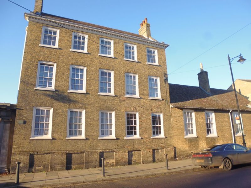
1082 ST MARY'S STREET
(North Side)
No 28 (formerly listed
as High School)
TL 5380 1/43 23.9.50.
II GV
2.
A large C18 yellow gault brick house with a good wood modillion eaves
cornice, 3 storeys and cellars. 5 window range, double hung sashes
with glazing bars, in flush cased frames. A single storey addition extends
on the east end with 3 window range and a stone Tuscan doorcase with
a coat of arms above, set in a pilastered panel. At the rear there is
a large circular brick bow with 3 tall sash windows, in stuccoed reveals,
and the interior has a C18 ornamental plaster cornice.
Nos 20, 22, 22A Nos 24 to 30 (even), Nos 34, 36, 36A, 38, Nos 40 to 60 (even)
form a group with Nos 13 to 29 (odd) & 29A, Parson's Almhouses & Nos 1 to
5 (odd) Downham Road.
Also Nos 20, 22, 22A, Nos 24 to 30 (even), Nos 34, 36, 36A, 38, Nos 40 to 60
(even), Nos 13 to 29 (odd) & 29A, Parson's Almshouses form a group with No 20
Church Lane & the Parish Church of St Mary.
Listing NGR: TL5387880396
External links are from the relevant listing authority and, where applicable, Wikidata. Wikidata IDs may be related buildings as well as this specific building. If you want to add or update a link, you will need to do so by editing the Wikidata entry.


Other nearby listed buildings
