Approximate Location Map
Large Map »
Latitude: 52.573 / 52°34'22"N
Longitude: -0.244 / 0°14'38"W
OS Eastings: 519098
OS Northings: 298685
OS Grid: TL190986
Mapcode National: GBR HZP.R3T
Mapcode Global: WHHNK.7L1C
Plus Code: 9C4XHQF4+59
Entry Name: 39, Cumbergate
Listing Date: 7 May 1973
Grade: II
Source: Historic England
Source ID: 1126961
English Heritage Legacy ID: 49620
ID on this website: 101126961
Location: Peterborough, Cambridgeshire, PE1
County: City of Peterborough
Electoral Ward/Division: Central
Parish: Non Civil Parish
Built-Up Area: Peterborough
Traditional County: Northamptonshire
Lieutenancy Area (Ceremonial County): Cambridgeshire
Church of England Parish: Peterborough St John the Baptist
Church of England Diocese: Peterborough
Tagged with: Building
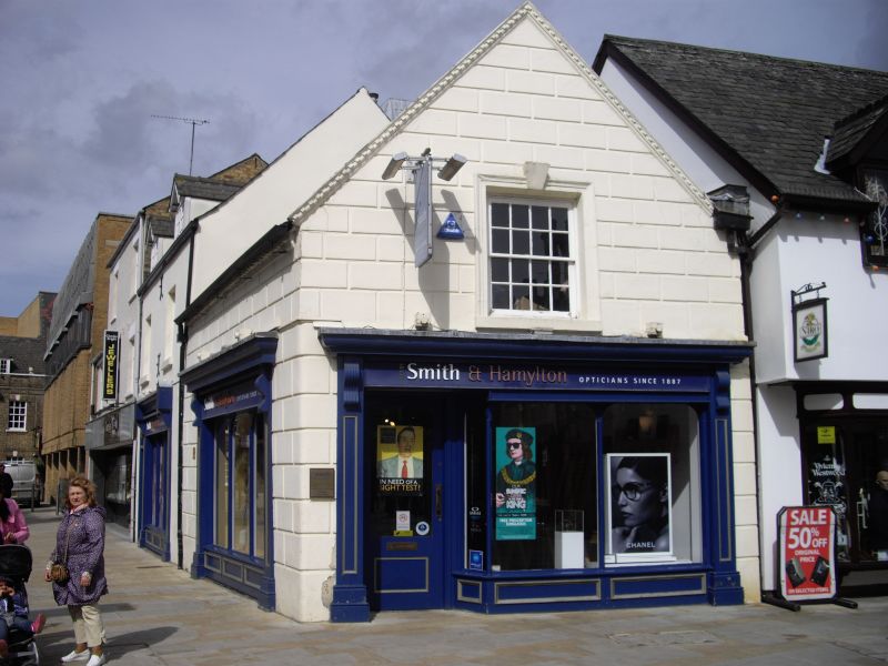
PETERBOROUGH
1.
1500 CUMBERGATE
(West Side)
No 39
TL 1998 NW 1/127
II GV
2.
Probably early C19 origin. 2 storeys. Rendered, carved as stone. Welsh slate
roof. Gable to road. Modern ground floor shop front with one window above, casement,
stone architrave with keystone, flush frame. Included solely for group value.
All the listed buildings in Cumbergate form a group.
Listing NGR: TL1909898685
External links are from the relevant listing authority and, where applicable, Wikidata. Wikidata IDs may be related buildings as well as this specific building. If you want to add or update a link, you will need to do so by editing the Wikidata entry.


Other nearby listed buildings
