Latitude: 52.1924 / 52°11'32"N
Longitude: -0.063 / 0°3'46"W
OS Eastings: 532496
OS Northings: 256679
OS Grid: TL324566
Mapcode National: GBR K5X.GW1
Mapcode Global: VHGMQ.V5J3
Plus Code: 9C4X5WRP+XQ
Entry Name: Manor Farmhouse
Listing Date: 31 August 1962
Grade: II*
Source: Historic England
Source ID: 1127209
English Heritage Legacy ID: 51028
ID on this website: 101127209
Location: Bourn, South Cambridgeshire, CB23
County: Cambridgeshire
District: South Cambridgeshire
Civil Parish: Bourn
Built-Up Area: Bourn
Traditional County: Cambridgeshire
Lieutenancy Area (Ceremonial County): Cambridgeshire
Church of England Parish: Bourn St Helena and St Mary
Church of England Diocese: Ely
Tagged with: Farmhouse
TL 3256-3356
15/1
31.8.62
BOURN
ALMS HILL
(East Side)
No 14
Manor Farmhouse
GV
II*
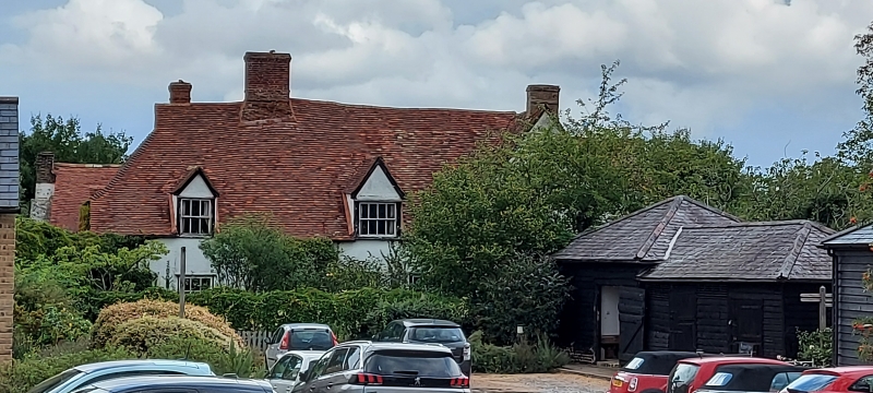
Farmhouse. Late C13, late medieval and early C17. Timber-framed cased, or
rebuilt in C19 gault brick. Plain tile roofs. Two rebuilt red brick ridge
stacks and painted brick end stack. One storey and attics find two storeys.
Irregular L-plan with crosswings to north-west and south-east. Main range of
south-east includes three bays of an aisled hall with later inserted floors
and chimney stack (for complete structural details see RCHM). North-west
elevation. Crosswing to left hand with painted brick external gable stack,
south-east range to right hand with gablet to hipped roof. Two doorways to
right and left hand with C20 doors, and with segmental brick arches. Door to
right hand with C19 canopy supported on shaped brackets. Three horizontal
sliding sash windows with small panes include two of three lights. One
gabled dormer window and one attic window both with horizontal sliding
sashes. The farmhouse was formerly owned by Christ's College, the C13 aisled
hall was probably Barnwell's manor-house rebuilt after it had been burnt in
1266 by Montfortian rebels raiding from the Isle of Ely.
R.C.H.M. West Cambs. p24, mon.8
V.C.H. Vol. V, p9
Listing NGR: TL3249656679
External links are from the relevant listing authority and, where applicable, Wikidata. Wikidata IDs may be related buildings as well as this specific building. If you want to add or update a link, you will need to do so by editing the Wikidata entry.


Other nearby listed buildings