Approximate Location Map
Large Map »
Latitude: 51.5398 / 51°32'23"N
Longitude: -2.3885 / 2°23'18"W
OS Eastings: 373154
OS Northings: 182395
OS Grid: ST731823
Mapcode National: GBR 0NJ.GYQ
Mapcode Global: VH95T.KK5F
Plus Code: 9C3VGJQ6+WJ
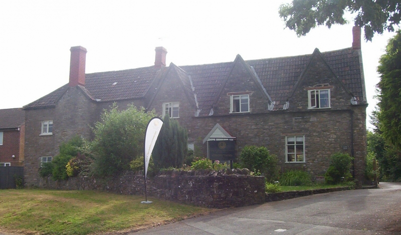
Entry Name: Vayre House
Listing Date: 29 July 1983
Grade: II
Source: Historic England
Source ID: 1129261
English Heritage Legacy ID: 34096
ID on this website: 101129261
Location: Chipping Sodbury, South Gloucestershire, BS37
County: South Gloucestershire
Civil Parish: Sodbury
Built-Up Area: Chipping Sodbury
Traditional County: Gloucestershire
Lieutenancy Area (Ceremonial County): Gloucestershire
Church of England Parish: Chipping Sodbury St John the Baptist
Church of England Diocese: Gloucester
Tagged with: House
ST 7382 SE SODBURY HATTER'S LANE
3/49 (south side)
Vayre House
II
Late C17 and later alterations. Rubble. Double Roman tiled roof. One storey and
attics in 3 gables. Three windows; C17 and C19 2-light timber casements. Adjoining
2-storey wing to left; 2 windows divided by lateral stack.
Listing NGR: ST7315482395
External links are from the relevant listing authority and, where applicable, Wikidata. Wikidata IDs may be related buildings as well as this specific building. If you want to add or update a link, you will need to do so by editing the Wikidata entry.


Other nearby listed buildings
