Approximate Location Map
Large Map »
Latitude: 51.5439 / 51°32'37"N
Longitude: -2.2838 / 2°17'1"W
OS Eastings: 380416
OS Northings: 182814
OS Grid: ST804828
Mapcode National: GBR 0NN.5DY
Mapcode Global: VH95W.CGJ9
Plus Code: 9C3VGPV8+HF
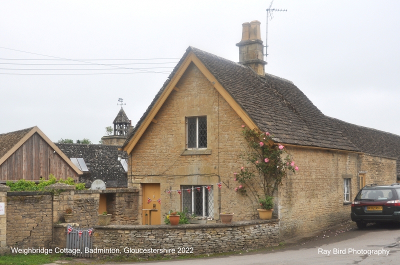
Entry Name: Farm Offices and 3 Ranges of Single Storey Buildings Which Enclose an Estate Yard, Including Saw Mill and Weighbridge Cottage
Listing Date: 10 November 1983
Grade: II
Source: Historic England
Source ID: 1129335
English Heritage Legacy ID: 34284
ID on this website: 101129335
Location: Badminton, South Gloucestershire, GL9
County: South Gloucestershire
Civil Parish: Badminton
Built-Up Area: Badminton
Traditional County: Gloucestershire
Lieutenancy Area (Ceremonial County): Gloucestershire
Church of England Parish: Badminton St Michael and All Angels
Church of England Diocese: Gloucester
Tagged with: Building
BADMINTON C.P. SHOP LANE (south side)
ST 8082
12/72 Farm Offices and 5 ranges of single
storey buildings which enclose an
G.V. estate yard, including Saw Mill and
Weighbridge Cottage
II
Farm offices and estate yard consisting of saw mill, workshops, store rooms and a
house (Weighbridge Cottage). Mid C19. The farm offices, formerly workshops
front the road: rubble, Cotswold stone slate roof and ashlar stacks; single
storey and attics in hipped dormers at rear; four 2- and 4-light casement windows
and 4 plank doors. To the right and rear is the saw mill: boarded walls and
slate and double Roman tiled roof; large sliding doors; rear wing and square
tower with an open octagonal timber bellcote under a slate roof. To the rear
of the offices and saw mill are 3 ranges of single storey sheds, of rubble and
with Cotswold stone slate roofs, which enclose the estate yard. West range,
begins with Weighbridge Cottage: coursed squared rubble; Cotswold stone slate
roof with plain bargeboards; central ashlar stack; single storey and attics in
2 gabled dormers; 2-light leaded casement windows. A shed of 8 open bays
adjoins the cottage and adjoining it to the south is a projecting gabled cartshed
and then a range of 8 bays with a central gabled opening, all with plank doors.
The south range consists of 8 bays with a gabled projecting entry to the left
which has a segmental headed doorway. The east range consists of 7 open bays
and a range of closed sheds which return to the farm offices. The east side
contains stables.
Listing NGR: ST8041682814
External links are from the relevant listing authority and, where applicable, Wikidata. Wikidata IDs may be related buildings as well as this specific building. If you want to add or update a link, you will need to do so by editing the Wikidata entry.


Other nearby listed buildings
