Latitude: 51.4624 / 51°27'44"N
Longitude: -2.3211 / 2°19'15"W
OS Eastings: 377791
OS Northings: 173757
OS Grid: ST777737
Mapcode National: GBR 0PL.80D
Mapcode Global: VH967.QH9T
Plus Code: 9C3VFM6H+WH
Entry Name: The Malting House and Former Malting House and Single Storey Workshops Range to Rear
Listing Date: 17 September 1952
Grade: II
Source: Historic England
Source ID: 1129430
English Heritage Legacy ID: 34510
ID on this website: 101129430
Location: Marshfield, South Gloucestershire, SN14
County: South Gloucestershire
Civil Parish: Marshfield
Built-Up Area: Marshfield
Traditional County: Gloucestershire
Lieutenancy Area (Ceremonial County): Gloucestershire
Church of England Parish: Marshfield
Church of England Diocese: Bristol
Tagged with: Architectural structure
MARSHFIELD C.P. HIGH STREET (north side)
ST 7773
13/97
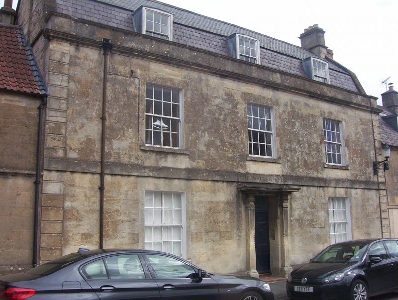
No. 78 (The Malting House)
17.9.52 and Former Malting House and
single storey workshops range
to rear
G.V. II
House in the village street and malthouse and outbuildings. Early - mid C19.
Ashlar; slate mansard roof with coped raised verges; moulded coped parapet and
moulded eaves cornice. 2 storeys and attics in dormers. 3 bays and
rusticated end pilasters, plain band over ground floor: 16-pane glazing bar sash
windows. Central 6 panel door under overlight; doorcase with reeded pilasters
and flat stone hood. To rear projects a former malting house: coursed squared
rubble; slate roof with coped raised verges; 2 storeys and basement; 5 bays,
2-light casement windows in freestone surrounds with arched heads, lead cames;
projecting first floor over arcade at south end. Across the yard is a range of
single storey workshops which match the malting house: 4 single light arched
windows and 3 plank doors in plain surrounds.
Listing NGR: ST7779173757
External links are from the relevant listing authority and, where applicable, Wikidata. Wikidata IDs may be related buildings as well as this specific building. If you want to add or update a link, you will need to do so by editing the Wikidata entry.


Other nearby listed buildings